Golop | |
|---|---|
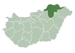
 Golop Location of Golop | |
| Coordinates: 48°14′14″N 21°11′19″E / 48.23716°N 21.18850°E | |
| Country | |
| County | Borsod-Abaúj-Zemplén |
| Area | |
| • Total | 9.43 km2 (3.64 sq mi) |
| Population (2004) | |
| • Total | 639 |
| • Density | 67.76/km2 (175.5/sq mi) |
| Time zone | UTC+1 (CET) |
| • Summer (DST) | UTC+2 (CEST) |
| Postal code | 3906 |
| Area code | 47 |
Golop is a village in Borsod-Abaúj-Zemplén county, Hungary.
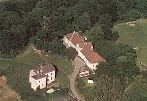
Aerial photography of the Castles of Golop
External links
- Street map (in Hungarian)
This article is issued from Wikipedia. The text is licensed under Creative Commons - Attribution - Sharealike. Additional terms may apply for the media files.