| Karasu River | |
|---|---|
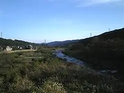 The Karasu River flowing through Takasaki | |
| Native name | 烏川 (Japanese) |
| Location | |
| Country | Japan |
| Physical characteristics | |
| Source | |
| • location | Hanamagari Mountain (Takasaki) |
| Mouth | |
• location | Tone River in Honjō, Saitama |
| Length | 61.8 km (38.4 mi) |
| Basin size | 470 km2 (180 sq mi) |
The Karasu River (烏川, Karasu-gawa) is a river located in Gunma Prefecture, Japan. It is a branch of the Tone River and the government of Japan classifies it as a Class 1 river. It generally flows in a south-easterly direction.
River communities
The river passes through or forms the boundary of the following communities:
- Gunma Prefecture
- Takasaki, Fujioka, Tamamura
- Nagano Prefecture
- Saku
- Saitama Prefecture
- Kamisato, Honjō
Scenic areas
The river runs through the Karasugawa Ravine in Takasaki, which has hiking trails for visitors to access the river.[1]
References
- ↑ Karasugawa Ravine Archived 2011-07-20 at the Wayback Machine. Takasaki City. Accessed October 24, 2010.
| |||||||||||||||
| |||||||||||||||
| |||||||||||||||
| |||||||||||||||
| |||||||||||||||
This article is issued from Wikipedia. The text is licensed under Creative Commons - Attribution - Sharealike. Additional terms may apply for the media files.