Kolsass | |
|---|---|
 | |
 Coat of arms | |
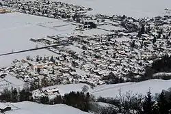
 Kolsass Location within Austria | |
| Coordinates: 47°18′01″N 11°37′51″E / 47.30028°N 11.63083°E | |
| Country | Austria |
| State | Tyrol |
| District | Innsbruck Land |
| Government | |
| • Mayor | Hansjörg Gartlacher |
| Area | |
| • Total | 3.34 km2 (1.29 sq mi) |
| Elevation | 553 m (1,814 ft) |
| Population (2018-01-01)[2] | |
| • Total | 1,626 |
| • Density | 490/km2 (1,300/sq mi) |
| Time zone | UTC+1 (CET) |
| • Summer (DST) | UTC+2 (CEST) |
| Postal code | 6114 |
| Area code | 05224 |
| Vehicle registration | IL |
| Website | www.kolsass.gv.at |
Kolsass is a municipality in the district Innsbruck-Land in the Austrian state of Tyrol located about 17 km east of Innsbruck. The location was first mentioned as „Quolesazz or Cholsasz" in 1050.
Population
| Year | Pop. | ±% |
|---|---|---|
| 1869 | 320 | — |
| 1880 | 322 | +0.6% |
| 1890 | 357 | +10.9% |
| 1900 | 369 | +3.4% |
| 1910 | 374 | +1.4% |
| 1923 | 417 | +11.5% |
| 1934 | 411 | −1.4% |
| 1939 | 411 | +0.0% |
| 1951 | 481 | +17.0% |
| 1961 | 641 | +33.3% |
| 1971 | 947 | +47.7% |
| 1981 | 1,143 | +20.7% |
| 1991 | 1,214 | +6.2% |
| 2001 | 1,411 | +16.2% |
| 2011 | 1,506 | +6.7% |
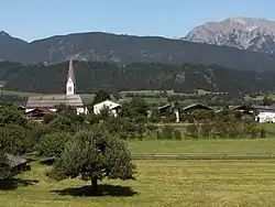
Kolsass, church: die Katholische Pfarrkirche Mariä Heimsuchung
References
- ↑ "Dauersiedlungsraum der Gemeinden Politischen Bezirke und Bundesländer - Gebietsstand 1.1.2018". Statistics Austria. Retrieved 10 March 2019.
- ↑ "Einwohnerzahl 1.1.2018 nach Gemeinden mit Status, Gebietsstand 1.1.2018". Statistics Austria. Retrieved 9 March 2019.
External links
Wikimedia Commons has media related to Kolsass.
This article is issued from Wikipedia. The text is licensed under Creative Commons - Attribution - Sharealike. Additional terms may apply for the media files.