Tulfes | |
|---|---|
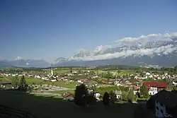 View of Tulfes | |
 Coat of arms | |
 Tulfes Location within Austria | |
| Coordinates: 47°15′25″N 11°31′49″E / 47.25694°N 11.53028°E | |
| Country | Austria |
| State | Tyrol |
| District | Innsbruck Land |
| Government | |
| • Mayor | Josef Gatt |
| Area | |
| • Total | 27.71 km2 (10.70 sq mi) |
| Elevation | 923 m (3,028 ft) |
| Population (2018-01-01)[2] | |
| • Total | 1,550 |
| • Density | 56/km2 (140/sq mi) |
| Time zone | UTC+1 (CET) |
| • Summer (DST) | UTC+2 (CEST) |
| Postal code | 6075 |
| Area code | 05223 |
| Vehicle registration | IL |
| Website | www |
Tulfes is a municipality in the district of Innsbruck-Land in the Austrian state of Tyrol, located 12 km east of Innsbruck and 6 km above Hall in Tirol. The village was mentioned as “Tellevo” for the first time in 1240. Main source of income is tourism. Tulfes became a popular area of settlement due to the cities of Innsbruck and Hall.
Population
| Year | Pop. | ±% |
|---|---|---|
| 1869 | 474 | — |
| 1880 | 518 | +9.3% |
| 1890 | 506 | −2.3% |
| 1900 | 500 | −1.2% |
| 1910 | 507 | +1.4% |
| 1923 | 545 | +7.5% |
| 1934 | 561 | +2.9% |
| 1939 | 541 | −3.6% |
| 1951 | 663 | +22.6% |
| 1961 | 640 | −3.5% |
| 1971 | 746 | +16.6% |
| 1981 | 968 | +29.8% |
| 1991 | 1,113 | +15.0% |
| 2001 | 1,302 | +17.0% |
| 2011 | 1,393 | +7.0% |
References
- ↑ "Dauersiedlungsraum der Gemeinden Politischen Bezirke und Bundesländer - Gebietsstand 1.1.2018". Statistics Austria. Retrieved 10 March 2019.
- ↑ "Einwohnerzahl 1.1.2018 nach Gemeinden mit Status, Gebietsstand 1.1.2018". Statistics Austria. Retrieved 9 March 2019.
External links
Wikimedia Commons has media related to Tulfes.
- Municipality Tulfes: Official website of the municipality in the Hall-Wattens region
This article is issued from Wikipedia. The text is licensed under Creative Commons - Attribution - Sharealike. Additional terms may apply for the media files.