Krakow, Wisconsin | |
|---|---|
Census-designated place | |
 Downtown Krakow | |
 Krakow, Wisconsin | |
| Coordinates: 44°45′42″N 88°15′05″W / 44.76167°N 88.25139°W | |
| Country | United States |
| State | Wisconsin |
| Counties | Oconto and Shawano |
| Area | |
| • Total | 1.128 sq mi (2.92 km2) |
| • Land | 1.128 sq mi (2.92 km2) |
| • Water | 0 sq mi (0 km2) |
| Elevation | 778 ft (237 m) |
| Population (2010) | |
| • Total | 354 |
| • Density | 310/sq mi (120/km2) |
| Time zone | UTC-6 (Central (CST)) |
| • Summer (DST) | UTC-5 (CDT) |
| ZIP code | 54137 |
| Area code | 920 |
| GNIS feature ID | 1565712[1] |

Sign along WIS 32
Krakow is an unincorporated community and census-designated place located primarily in Shawano County, Wisconsin, United States, with a small portion in Oconto County. Krakow is located on Wisconsin Highway 32 north of Pulaski, in the towns of Chase, and Angelica. Krakow has a post office with ZIP code 54137.[2] As of the 2010 census, its population is 354.[3] Krakow has a Catholic church and a tavern. In its heyday, Krakow had a grocery store, cheese factory, pickle canning company, movie theaters, and a few taverns, a parochial and a public schools.
Demographics
References
Municipalities and communities of Oconto County, Wisconsin, United States | ||
|---|---|---|
| Cities | 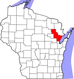 | |
| Villages | ||
| Towns | ||
| CDPs | ||
| Other communities | ||
| Indian reservation | ||
| Footnotes | ‡This populated place also has portions in an adjacent county or counties | |
Municipalities and communities of Shawano County, Wisconsin, United States | ||
|---|---|---|
| Cities | 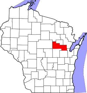 | |
| Villages | ||
| Towns | ||
| CDPs | ||
| Other communities | ||
| Indian reservations | ||
| Footnotes | ‡This populated place also has portions in an adjacent county or counties | |
This article is issued from Wikipedia. The text is licensed under Creative Commons - Attribution - Sharealike. Additional terms may apply for the media files.