Kuničky | |
|---|---|
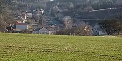 View from the west | |
 Flag  Coat of arms | |
 Kuničky Location in the Czech Republic | |
| Coordinates: 49°26′6″N 16°40′53″E / 49.43500°N 16.68139°E | |
| Country | |
| Region | South Moravian |
| District | Blansko |
| First mentioned | 1378 |
| Area | |
| • Total | 4.29 km2 (1.66 sq mi) |
| Elevation | 530 m (1,740 ft) |
| Population (2023-01-01)[1] | |
| • Total | 277 |
| • Density | 65/km2 (170/sq mi) |
| Time zone | UTC+1 (CET) |
| • Summer (DST) | UTC+2 (CEST) |
| Postal code | 679 02 |
| Website | www |
Kuničky is a municipality and village in Blansko District in the South Moravian Region of the Czech Republic. It has about 300 inhabitants.
Kuničky lies approximately 8 kilometres (5 mi) north of Blansko, 27 km (17 mi) north of Brno, and 179 km (111 mi) south-east of Prague.
References
Wikimedia Commons has media related to Kuničky.
This article is issued from Wikipedia. The text is licensed under Creative Commons - Attribution - Sharealike. Additional terms may apply for the media files.