Kunlong | |
|---|---|
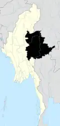
 Kunlong Location in Burma | |
| Coordinates: 23°25′20″N 98°39′10″E / 23.42222°N 98.65278°E | |
| Country | |
| State | Shan State |
| Elevation | 489 m (1,604 ft) |
| Time zone | UTC+6.30 (MST) |
Kunlong District was a district of the Shan State in Myanmar. It was dissolved in November 2014. It consists of 2 towns and 458 villages. The main road of the District, Hsenwi-Kunlong-Chinshwehaw road, is 66 miles (106 kilometres) long.[2]
Townships
The district contained the following townships:
Hopang Township became part of Hopang District and is now not anymore under Kunlong District since September 2011.[3] Now Kunlong District just consists of Kunlong Township
References

This article is issued from Wikipedia. The text is licensed under Creative Commons - Attribution - Sharealike. Additional terms may apply for the media files.