| Mount Naeba | |
|---|---|
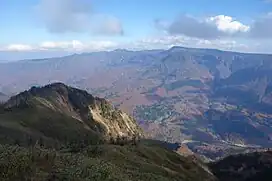 Naeba Volcano seen from the west | |
| Highest point | |
| Elevation | 2,145.3 m (7,038 ft) |
| Listing | List of mountains and hills of Japan by height |
| Coordinates | 36°50′45″N 138°41′25″E / 36.84583°N 138.69028°E |
| Naming | |
| Native name | 苗場山 (Japanese) |
| Geography | |
| Parent range | Mikuni Mountains |
| Topo map | Geographical Survey Institute 25000:1 苗場山, 50000:1 高田 |
| Climbing | |
| Easiest route | Hike |

Mount Naeba (苗場山, Naeba-san) is a stratovolcano[1] on the border of Nagano and Niigata prefectures in central Honshū, Japan. It is about 200 km (124 mi) from Tokyo. It was active between 200,000 and 800,000 years ago.[1] It is primarily made of andesite.[1]
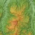 Relief map of Naeba Volcano.
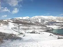 Naeba Volcano seen from the east.
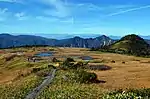 The wetland area of Mount Naeba.
See also
References
- 1 2 3 "NAEBA-SAN". Quaternary Volcanoes of Japan. Geological Survey of Japan, AIST. 2006. Archived from the original on 2012-07-22. Retrieved 2008-12-21.
External links
 Media related to Mount Naeba at Wikimedia Commons
- "Naeba". Global Volcanism Program. Smithsonian Institution. Retrieved 2021-06-24.
- Naeba San - Geological Survey of Japan
| Hokkaidō | |||||||||
|---|---|---|---|---|---|---|---|---|---|
| Tōhoku region Jōshinetsu region |
| ||||||||
| Kantō region | |||||||||
| Chūbu region |
| ||||||||
| Western Japan | |||||||||
| |||||||||
This article is issued from Wikipedia. The text is licensed under Creative Commons - Attribution - Sharealike. Additional terms may apply for the media files.