| Mount Nasu | |
|---|---|
| 那須岳 | |
 Nasu Mountains | |
| Highest point | |
| Peak | Sanbonyari Peak |
| Elevation | 1,916.9 m (6,289 ft)[1] |
| Listing | Mountains of Japan |
| Coordinates | 37°09′N 139°57′E / 37.150°N 139.950°E |
| Naming | |
| Language of name | Japanese |
| Geography | |
 Mount Nasu On the border of Nasushiohara and Nasu of Tochigi Prefecture, Nishigō, Nishishirakawa of Fukushima Prefecture, Japan | |
| Parent range | Ōu Mountains |
| Geology | |
| Mountain type | Complex volcano |
| Last eruption | November 1963[2] |
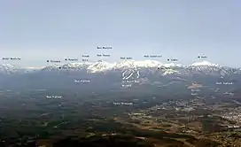
Mount Nasu (那須岳, Nasu-dake) is a group of complex volcanoes located in the northeast part of Nikkō National Park, Japan. The tallest peak is Sanbonyari Peak at a height of 1,916.9 m (6,289 ft). Mount Nasu is one of the 100 Famous Japanese Mountains.
Major peaks
Mount Nasu has the following major peaks:
- Sanbonyari Peak – 1916.9 m
- Chausu Peak – 1915 m
- Asahi Peak – 1896 m
- Minamigatsusan – 1776 m
- Kuro-oya Peak – 1589 m
These peaks are known collectively as Nasu Five Peaks (那須5岳, Nasu-Go-Take).
Climate
| Climate data for Mount Nasu (1991−2020 normals, extremes 1976−present) | |||||||||||||
|---|---|---|---|---|---|---|---|---|---|---|---|---|---|
| Month | Jan | Feb | Mar | Apr | May | Jun | Jul | Aug | Sep | Oct | Nov | Dec | Year |
| Record high °C (°F) | 12.7 (54.9) |
16.8 (62.2) |
21.1 (70.0) |
26.8 (80.2) |
29.6 (85.3) |
30.3 (86.5) |
31.8 (89.2) |
32.2 (90.0) |
29.5 (85.1) |
24.6 (76.3) |
20.0 (68.0) |
17.4 (63.3) |
32.2 (90.0) |
| Mean daily maximum °C (°F) | 1.9 (35.4) |
2.7 (36.9) |
6.8 (44.2) |
13.0 (55.4) |
18.2 (64.8) |
20.7 (69.3) |
24.3 (75.7) |
25.4 (77.7) |
21.4 (70.5) |
16.1 (61.0) |
10.9 (51.6) |
5.1 (41.2) |
13.9 (57.0) |
| Daily mean °C (°F) | −1.7 (28.9) |
−1.3 (29.7) |
2.0 (35.6) |
7.8 (46.0) |
13.0 (55.4) |
16.4 (61.5) |
20.2 (68.4) |
21.0 (69.8) |
17.3 (63.1) |
11.8 (53.2) |
6.4 (43.5) |
1.1 (34.0) |
9.5 (49.1) |
| Mean daily minimum °C (°F) | −5.3 (22.5) |
−5.3 (22.5) |
−2.4 (27.7) |
2.6 (36.7) |
7.7 (45.9) |
12.3 (54.1) |
16.7 (62.1) |
17.5 (63.5) |
13.8 (56.8) |
7.7 (45.9) |
2.0 (35.6) |
−2.6 (27.3) |
5.4 (41.7) |
| Record low °C (°F) | −11.7 (10.9) |
−12.1 (10.2) |
−10.4 (13.3) |
−6.0 (21.2) |
−2.3 (27.9) |
3.6 (38.5) |
8.7 (47.7) |
8.9 (48.0) |
3.2 (37.8) |
−1.2 (29.8) |
−6.1 (21.0) |
−10.2 (13.6) |
−12.1 (10.2) |
| Average precipitation mm (inches) | 52.6 (2.07) |
42.8 (1.69) |
101.6 (4.00) |
139.6 (5.50) |
180.8 (7.12) |
220.5 (8.68) |
305.7 (12.04) |
303.9 (11.96) |
305.3 (12.02) |
212.6 (8.37) |
89.2 (3.51) |
60.1 (2.37) |
2,014.7 (79.33) |
| Average snowfall cm (inches) | 103 (41) |
79 (31) |
45 (18) |
7 (2.8) |
0 (0) |
0 (0) |
0 (0) |
0 (0) |
0 (0) |
0 (0) |
4 (1.6) |
55 (22) |
293 (116.4) |
| Average precipitation days (≥ 1.0 mm) | 9.1 | 8.3 | 10.4 | 11.3 | 12.1 | 15.9 | 18.3 | 17.0 | 14.8 | 11.5 | 8.3 | 9.1 | 146.1 |
| Average snowy days (≥ 1 cm) | 11.5 | 8.8 | 5.5 | 0.6 | 0 | 0 | 0 | 0 | 0 | 0 | 0.4 | 5.9 | 32.7 |
| Mean monthly sunshine hours | 131.0 | 129.0 | 156.4 | 170.4 | 169.1 | 108.8 | 98.7 | 115.3 | 98.9 | 115.1 | 130.1 | 132.6 | 1,555.2 |
| Source 1: JMA[3] | |||||||||||||
| Source 2: JMA[4] | |||||||||||||
Eruption
It is estimated that Mount Nasu started erupting 600 thousand years ago. The eruption started from the north end of the mountain range, at Kashi-Asahi Peak. Only Chausu Peak is active today.
Access
- Nasu Sancho Station of Nasu Ropeway
- Sandogoya Onsen Bus Stop of Kanto Transportation
Gallery
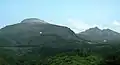 Chausu lava dome and Asahi Peak
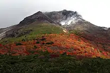 Chausu lava dome and fumes
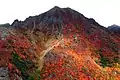 Asahi Peak
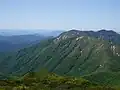 West view from Sanbonyari Peak
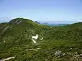 Sanbonyari Peak and snow in summer
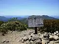 At the Sanbonyari Peak
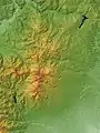 Topographic map
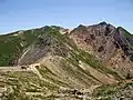 To Asahi Peak
References
- ↑ "Topographic map of Mount Nasu". opentopomap.org. Retrieved 2023-06-12.
- ↑ "Nasudake". Global Volcanism Program. Smithsonian Institution. Retrieved 2021-06-24.
- ↑ 観測史上1~10位の値(年間を通じての値). JMA. Retrieved February 18, 2022.
- ↑ 気象庁 / 平年値(年・月ごとの値). JMA. Retrieved February 18, 2022.
External links
Wikimedia Commons has media related to Mount Nasu.
- Nasudake – Japan Meteorological Agency (in Japanese)
- "Nasudake: National catalogue of the active volcanoes in Japan" (PDF). – Japan Meteorological Agency
- Nasudake – Geological Survey of Japan
| Hokkaidō | |||||||||
|---|---|---|---|---|---|---|---|---|---|
| Tōhoku region Jōshinetsu region |
| ||||||||
| Kantō region | |||||||||
| Chūbu region |
| ||||||||
| Western Japan | |||||||||
| |||||||||
This article is issued from Wikipedia. The text is licensed under Creative Commons - Attribution - Sharealike. Additional terms may apply for the media files.