Olterterp | |
|---|---|
Village | |
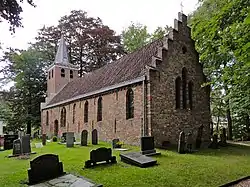 Saint-Hippolytus in Olterterp, 15th century | |
 Coat of arms | |
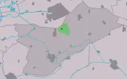 Location in Opsterland municipality | |
 Olterterp Location in the Netherlands  Olterterp Olterterp (Netherlands) | |
| Coordinates: 53°03′59″N 6°6′13″E / 53.06639°N 6.10361°E | |
| Country | |
| Province | |
| Municipality | |
| Area | |
| • Total | 6.20 km2 (2.39 sq mi) |
| Elevation | 1.9 m (6.2 ft) |
| Population (2021)[1] | |
| • Total | 80 |
| • Density | 13/km2 (33/sq mi) |
| Postal code | 9246[1] |
| Dialing code | 0512 |
Olterterp is a village in the municipality of Opsterland in the east of Friesland, the Netherlands. It had a population of around 75 in January 2017.[3]
The village was first mentioned in 1505 as Otterterp, and means "outer settlement".[4] The Dutch Reformed church was built in 1414 or 1415 as a replacement of an earlier church. The church was built without a tower. The tower was added in 1744.[5]
Olterterp was home to 154 people in 1840.[5] Most of the land was owned by Ambrosius Ayso van Boelens. Around 1850, van Boelens started to cultivate the wilderness and turn it into farmland.[6]
Gallery
.jpg.webp) Restaurant Wite Hûs
Restaurant Wite Hûs Farm in Olterterp
 De Horst
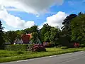 Klein Olderterp
References
- 1 2 3 "Kerncijfers wijken en buurten 2021". Central Bureau of Statistics. Retrieved 2 April 2022.
- ↑ "Postcodetool for 9246TL". Actueel Hoogtebestand Nederland (in Dutch). Het Waterschapshuis. Retrieved 2 April 2022.
- ↑ Kerncijfers wijken en buurten 2017 - CBS Statline
- ↑ "Olterterp - (geografische naam)". Etymologiebank (in Dutch). Retrieved 2 April 2022.
- 1 2 "Olterterp". Plaatsengids (in Dutch). Retrieved 2 April 2022.
- ↑ "Olterterp". Friesland Wonderland (in Dutch). Retrieved 2 March 2022.
External links
![]() Media related to Olterterp at Wikimedia Commons
Media related to Olterterp at Wikimedia Commons
This article is issued from Wikipedia. The text is licensed under Creative Commons - Attribution - Sharealike. Additional terms may apply for the media files.