Puyusca
Phuyusqa | |
|---|---|
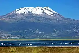 Sara Sara, the highest mountain of the district, as seen from Parinaqucha | |
| Country | |
| Region | Ayacucho |
| Province | Parinacochas |
| Founded | March 5, 1954 |
| Capital | Incuyo |
| Government | |
| • Mayor | Yony Odon Reyes Anampa |
| Area | |
| • Total | 700.75 km2 (270.56 sq mi) |
| Elevation | 3,290 m (10,790 ft) |
| Population | |
| • Total | 3,055 |
| • Density | 4.4/km2 (11/sq mi) |
| Time zone | UTC-5 (PET) |
| UBIGEO | 050706 |
Puyusca (Quechua: Phuyusqa, meaning "cloudy") is one of eight districts of the Parinacochas Province in Peru.[1]
Geography
One of the highest elevations of the district is glacier-covered Sara Sara volcano at 5,505 m (18,061 ft). Other mountains are listed below:[2]
- Hatun Urqu
- Kuntur Sirk'a
- Pichqa
- Pisti
- Puka Puka
- Phuyusqa
- Qiñwa Punta
- Ruphaylla
- Sara Qutuna
- Saywa Pampa
- Uywa Qhawarina
- Wamantirka
Ethnic groups
The people in the district are mainly indigenous citizens of Quechua descent. Quechua is the language which the majority of the population (62.54%) learnt to speak in childhood, 36.97% of the residents started speaking using the Spanish language (2007 Peru Census).[3]
See also
References
- ↑ (in Spanish) Instituto Nacional de Estadística e Informática. Banco de Información Distrital Archived 2008-04-23 at the Wayback Machine. Retrieved April 11, 2008.
- ↑ escale.minedu.gob.pe - UGEL maps of the Parinacochas Province, Ayacucho Region
- ↑ inei.gob.pe Archived 2013-01-27 at the Wayback Machine INEI, Peru, Censos Nacionales 2007, Frequencias: Preguntas de Población: Idioma o lengua con el que aprendió hablar (in Spanish)
| |
|---|---|
| Cangallo | |
| Huamanga | |
| Huanca Sancos | |
| Huanta | |
| La Mar | |
| Lucanas | |
| Parinacochas | |
| Paucar del Sara Sara | |
| Sucre | |
| Víctor Fajardo | |
| Vilcas Huamán | |
This article is issued from Wikipedia. The text is licensed under Creative Commons - Attribution - Sharealike. Additional terms may apply for the media files.