Route 325 | ||||
|---|---|---|---|---|
 | ||||
| Route information | ||||
| Maintained by Transports Québec | ||||
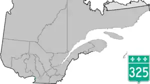
| Length | 42.0 km[1] (26.1 mi) | |||
| Major junctions | ||||
| South end | ||||
| North end | ||||
| Location | ||||
| Country | Canada | |||
| Province | Quebec | |||
| Highway system | ||||
| ||||

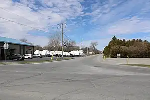
L'intersection de la 325 et 338, avec vue sur la 325
Route 325 is a Quebec provincial highway located in the Montérégie region near the Ontario-Quebec border. The 43-kilometer highway runs from south to north from Rivière-Beaudette at the junction of Route 338 (just south of Autoroute 20) to Rigaud at the junction of Route 342.
Municipalities along Route 325
Major intersections
| RCM or ET | Municipality | Km | Junction | Notes |
|---|---|---|---|---|
Southern terminus of Route 325 | ||||
| Vaudreuil-Soulanges | Rivière-Beaudette | 0.0 | 338 WEST: to South Glengarry, Ontario 338 EAST: to Saint-Zotique | |
| 0.6 0.9 |
20 EAST: to Saint-Zotique 20 WEST: to South Glengarry, Ontario | |||
| Saint-Télesphore | 10.6 | 340 WEST: to South Glengarry, Ontario 340 EAST: to Saint-Polycarpe | ||
| Sainte-Justine-de-Newton | 21.2 | Chemin Bedard | WEST: to North Glengarry, Ontario | |
| Très-Saint-Rédempteur | 31.0 | Chemin du Ruban | WEST: to East Hawkesbury, Ontario | |
| Rigaud | 42.0 | 342 WEST: to Pointe-Fortune 342 EAST: to Saint-Lazare | ||
Northern terminus of Route 325 | ||||
See also
References
- ↑ Ministère des transports, "Distances routières", page 96-97, Les Publications du Québec, 2005
External links
- Official Transport Quebec Road Map (in French)
- Route 325 on Google Maps
This article is issued from Wikipedia. The text is licensed under Creative Commons - Attribution - Sharealike. Additional terms may apply for the media files.