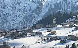
Raggal | |
|---|---|
 | |
 Coat of arms | |
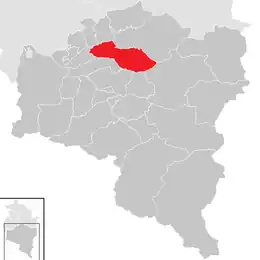 Location in the district | |
 Raggal Location within Austria | |
| Coordinates: 47°13′00″N 09°49′00″E / 47.21667°N 9.81667°E | |
| Country | Austria |
| State | Vorarlberg |
| District | Bludenz |
| Government | |
| • Mayor | Hermann Manahl |
| Area | |
| • Total | 41.69 km2 (16.10 sq mi) |
| Elevation | 1,015 m (3,330 ft) |
| Population (2018-01-01)[2] | |
| • Total | 868 |
| • Density | 21/km2 (54/sq mi) |
| Time zone | UTC+1 (CET) |
| • Summer (DST) | UTC+2 (CEST) |
| Postal code | 6741 |
| Area code | 05553 |
| Vehicle registration | BZ |
| Website | www.raggal.at |
Raggal is a municipality in the district of Bludenz in the Austrian state of Vorarlberg.
Population
| Year | Pop. | ±% |
|---|---|---|
| 1869 | 761 | — |
| 1880 | 651 | −14.5% |
| 1890 | 536 | −17.7% |
| 1900 | 512 | −4.5% |
| 1910 | 508 | −0.8% |
| 1923 | 512 | +0.8% |
| 1934 | 546 | +6.6% |
| 1939 | 570 | +4.4% |
| 1951 | 618 | +8.4% |
| 1961 | 612 | −1.0% |
| 1971 | 695 | +13.6% |
| 1981 | 744 | +7.1% |
| 1991 | 810 | +8.9% |
| 2001 | 863 | +6.5% |
| 2011 | 832 | −3.6% |
References
- ↑ "Dauersiedlungsraum der Gemeinden Politischen Bezirke und Bundesländer - Gebietsstand 1.1.2018". Statistics Austria. Retrieved 10 March 2019.
- ↑ "Einwohnerzahl 1.1.2018 nach Gemeinden mit Status, Gebietsstand 1.1.2018". Statistics Austria. Retrieved 9 March 2019.
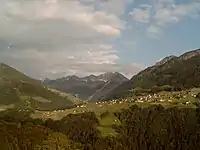
Raggal, view to the village
Wikimedia Commons has media related to Raggal.
This article is issued from Wikipedia. The text is licensed under Creative Commons - Attribution - Sharealike. Additional terms may apply for the media files.