| Rio Grande Pyramid | |
|---|---|
 | |
| Highest point | |
| Elevation | 13,827 ft (4,214 m)[1][2] |
| Prominence | 1,881 ft (573 m)[3] |
| Isolation | 10.76 mi (17.32 km)[3] |
| Listing | |
| Coordinates | 37°40′47″N 107°23′33″W / 37.6797018°N 107.3924291°W[1] |
| Geography | |
 Rio Grande Pyramid | |
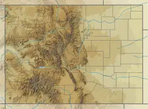
| Location | Hinsdale County, Colorado, U.S.[4] |
| Parent range | San Juan Mountains[3] |
| Topo map | USGS 7.5' topographic map Rio Grande Pyramid, Colorado[1] |
| Climbing | |
| First ascent | 1874 by the Wheeler Survey |
| Easiest route | Hike (class 2[5]) |
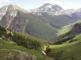
Rio Grande Pyramid, elevation 13,827 feet, is a summit in the San Juan Mountains of southwest Colorado. The peak is in the Weminuche Wilderness of the San Juan National Forest northeast of Durango.
See also
References
- 1 2 3 "PYRAMID". NGS Data Sheet. National Geodetic Survey, National Oceanic and Atmospheric Administration, United States Department of Commerce. Retrieved October 22, 2014.
- ↑ The elevation of Rio Grande Pyramid includes an adjustment of +1.801 m (+5.91 ft) from NGVD 29 to NAVD 88.
- 1 2 3 "Rio Grande Pyramid, Colorado". Peakbagger.com. Retrieved October 22, 2014.
- ↑ "Rio Grande Pyramid". Geographic Names Information System. United States Geological Survey, United States Department of the Interior. Retrieved November 13, 2014.
- ↑ "Rio Grande Pyramid - Mountain Summits on". Waymarking.com. Retrieved 2022-05-03.
External links
|
Denver (capital) | |
| Topics |
|
| Society | |
| Cities |
|
| Counties |
|
| Regions |
|
This article is issued from Wikipedia. The text is licensed under Creative Commons - Attribution - Sharealike. Additional terms may apply for the media files.