Saint-Bonnet-de-Chirac | |
|---|---|
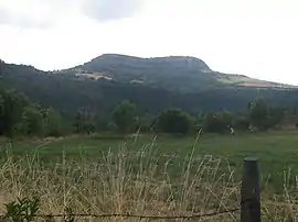 The Truc de Saint-Bonnet-de-Chirac at 942 m (3,091 ft) | |
Location of Saint-Bonnet-de-Chirac | |
 Saint-Bonnet-de-Chirac  Saint-Bonnet-de-Chirac | |
| Coordinates: 44°30′51″N 3°17′02″E / 44.5142°N 3.2839°E | |
| Country | France |
| Region | Occitania |
| Department | Lozère |
| Arrondissement | Mende |
| Canton | Bourgs sur Colagne |
| Intercommunality | Gévaudan |
| Government | |
| • Mayor (2020–2026) | Isabelle Recoulin[1] |
| Area 1 | 7.68 km2 (2.97 sq mi) |
| Population | 71 |
| • Density | 9.2/km2 (24/sq mi) |
| Time zone | UTC+01:00 (CET) |
| • Summer (DST) | UTC+02:00 (CEST) |
| INSEE/Postal code | 48138 /48100 |
| Elevation | 579–960 m (1,900–3,150 ft) (avg. 650 m or 2,130 ft) |
| 1 French Land Register data, which excludes lakes, ponds, glaciers > 1 km2 (0.386 sq mi or 247 acres) and river estuaries. | |
Saint-Bonnet-de-Chirac (French pronunciation: [sɛ̃ bɔnɛ də ʃiʁak]; Occitan: Sant Bonet) is a commune in the Lozère department in southern France.[3]
Geography
The Colagne forms part of the commune's south-western border, then flows into the Lot, which forms part of the commune's southern border.
See also
References
- ↑ "Répertoire national des élus: les maires" (in French). data.gouv.fr, Plateforme ouverte des données publiques françaises. 13 September 2022.
- ↑ "Populations légales 2021". The National Institute of Statistics and Economic Studies. 28 December 2023.
- ↑ INSEE commune file
Wikimedia Commons has media related to Saint-Bonnet-de-Chirac.
This article is issued from Wikipedia. The text is licensed under Creative Commons - Attribution - Sharealike. Additional terms may apply for the media files.