Tossicia | |
|---|---|
| Comune di Tossicia | |
 | |
Location of Tossicia | |
 Tossicia Location of Tossicia in Italy 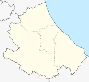 Tossicia Tossicia (Abruzzo) | |
| Coordinates: 42°33′N 13°39′E / 42.550°N 13.650°E | |
| Country | Italy |
| Region | Abruzzo |
| Province | Teramo (TE) |
| Frazioni | Aquilano, Azzinano, Case di Renzo, Chiarino, Flamignano, Garisciano, Paduli, Palozza, Petrignano, Cerquone, Camerale, Colledonico (partly in the comune of Montorio al Vomano), Tozzanella. |
| Government | |
| • Mayor | Franco Tarquini |
| Area | |
| • Total | 27.14 km2 (10.48 sq mi) |
| Elevation | 409 m (1,342 ft) |
| Population (1 January 2016)[2] | |
| • Total | 1,406 |
| • Density | 52/km2 (130/sq mi) |
| Demonym | Tossiciani |
| Time zone | UTC+1 (CET) |
| • Summer (DST) | UTC+2 (CEST) |
| Postal code | 64049 |
| Dialing code | 0861 |
| Patron saint | Santa Sinforosa |
| Saint day | 18 July |
| Website | Official website |
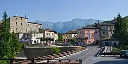
Tossicia (Abruzzese: Tussëcië) is a town and comune in province of Teramo in the Abruzzo region of eastern Italy. It is located in the natural park known as the "Gran Sasso e Monti della Laga National Park".
References
- ↑ "Superficie di Comuni Province e Regioni italiane al 9 ottobre 2011". Italian National Institute of Statistics. Retrieved 16 March 2019.
- ↑ All demographics and other statistics from the Italian statistical institute (Istat)

This article is issued from Wikipedia. The text is licensed under Creative Commons - Attribution - Sharealike. Additional terms may apply for the media files.