Tredozio | |
|---|---|
| Comune di Tredozio | |
Location of Tredozio | |
 Tredozio Location of Tredozio in Italy 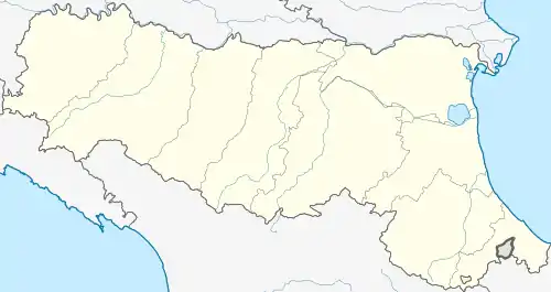 Tredozio Tredozio (Emilia-Romagna) | |
| Coordinates: 44°5′N 11°45′E / 44.083°N 11.750°E | |
| Country | Italy |
| Region | Emilia-Romagna |
| Province | Forlì-Cesena (FC) |
| Frazioni | San Valentino , Rocca Modigliana , Madonna della Neve |
| Government | |
| • Mayor | Simona Vietina |
| Area | |
| • Total | 62.4 km2 (24.1 sq mi) |
| Highest elevation | 998 m (3,274 ft) |
| Lowest elevation | 360 m (1,180 ft) |
| Population (31 May 2007)[2] | |
| • Total | 1,296 |
| • Density | 21/km2 (54/sq mi) |
| Demonym | Tredoziesi |
| Time zone | UTC+1 (CET) |
| • Summer (DST) | UTC+2 (CEST) |
| Postal code | 47019 |
| Dialing code | 0546 |
| Patron saint | Our Lady of Graces |
| Saint day | May, the second sunday |
| Website | Official website |
Tredozio (Romagnol: Tardozî) is a comune (municipality) in the Province of Forlì-Cesena in the Italian region Emilia-Romagna, located about 60 kilometres (37 mi) southeast of Bologna and about 30 kilometres (19 mi) southwest of Forlì.
Tredozio borders the following municipalities: Marradi, Modigliana, Portico e San Benedetto, Rocca San Casciano.
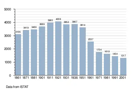
Demographic evolution
Twin towns
References
- ↑ "Superficie di Comuni Province e Regioni italiane al 9 ottobre 2011". Italian National Institute of Statistics. Retrieved 16 March 2019.
- ↑ All demographics and other statistics: Italian statistical institute Istat.
External links
This article is issued from Wikipedia. The text is licensed under Creative Commons - Attribution - Sharealike. Additional terms may apply for the media files.