Valmanya | |
|---|---|
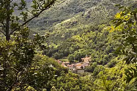 A general view of Valmanya | |
.svg.png.webp) Coat of arms | |
Location of Valmanya | |
 Valmanya  Valmanya | |
| Coordinates: 42°32′21″N 2°32′06″E / 42.5392°N 2.535°E | |
| Country | France |
| Region | Occitania |
| Department | Pyrénées-Orientales |
| Arrondissement | Prades |
| Canton | Le Canigou |
| Intercommunality | Conflent-Canigó |
| Government | |
| • Mayor (2022–2026) | Serge Boyer[1] |
| Area 1 | 27.63 km2 (10.67 sq mi) |
| Population | 34 |
| • Density | 1.2/km2 (3.2/sq mi) |
| Time zone | UTC+01:00 (CET) |
| • Summer (DST) | UTC+02:00 (CEST) |
| INSEE/Postal code | 66221 /66320 |
| Elevation | 692–2,720 m (2,270–8,924 ft) (avg. 901 m or 2,956 ft) |
| 1 French Land Register data, which excludes lakes, ponds, glaciers > 1 km2 (0.386 sq mi or 247 acres) and river estuaries. | |
Valmanya (French pronunciation: [valmaɲa] ⓘ; Catalan: Vallmanya) is a commune in the Pyrénées-Orientales department in southern France.
Geography
Valmanya is located in the canton of Le Canigou and in the arrondissement of Prades.
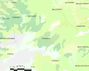
Map of Valmanya and its surrounding communes
Population
| Year | Pop. | ±% p.a. |
|---|---|---|
| 1968 | 63 | — |
| 1975 | 29 | −10.49% |
| 1982 | 32 | +1.42% |
| 1990 | 30 | −0.80% |
| 1999 | 18 | −5.52% |
| 2007 | 27 | +5.20% |
| 2012 | 44 | +10.26% |
| 2017 | 34 | −5.03% |
| Source: INSEE[3] | ||
See also
References
- ↑ "Répertoire national des élus: les maires" (in French). data.gouv.fr, Plateforme ouverte des données publiques françaises. 6 June 2023.
- ↑ "Populations légales 2021". The National Institute of Statistics and Economic Studies. 28 December 2023.
- ↑ Population en historique depuis 1968, INSEE
Wikimedia Commons has media related to Valmanya.
This article is issued from Wikipedia. The text is licensed under Creative Commons - Attribution - Sharealike. Additional terms may apply for the media files.