Čagona | |
|---|---|
 Čagona Location in Slovenia | |
| Coordinates: 46°32′54.58″N 15°55′30.32″E / 46.5484944°N 15.9250889°E | |
| Country | |
| Traditional region | Styria |
| Statistical region | Drava |
| Municipality | Cerkvenjak |
| Area | |
| • Total | 3.34 km2 (1.29 sq mi) |
| Elevation | 267.8 m (878.6 ft) |
| Population (2020) | |
| • Total | 235 |
| [1] | |
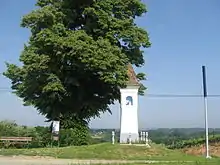
Plague columns in Čagona
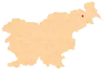
Čagona (pronounced [ˈtʃaːɡɔna], German: Tschaga[2]) is a settlement in the Municipality of Cerkvenjak in northeastern Slovenia. It lies on the edge of the Slovene Hills (Slovene: Slovenske gorice) and partly in the Pesnica Valley. The area is part of the traditional region of Styria and is now included in the Drava Statistical Region.[3]
References
- ↑ Statistical Office of the Republic of Slovenia
- ↑ Leksikon občin kraljestev in dežel zastopanih v državnem zboru, vol. 4: Štajersko. Vienna: C. Kr. Dvorna in Državna Tiskarna. 1904. p. 212.
- ↑ Cerkvenjak municipal site
External links
 Media related to Čagona at Wikimedia Commons
- Čagona on Geopedia
| Settlements | Administrative seat: Cerkvenjak
|  |
|---|---|---|
| Landmarks |
| |
This article is issued from Wikipedia. The text is licensed under Creative Commons - Attribution - Sharealike. Additional terms may apply for the media files.