Municipality of Cerkvenjak
Občina Cerkvenjak | |
|---|---|
.jpg.webp) | |
 Coat of arms | |
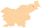
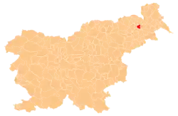 Location of the Municipality of Cerkvenjak in Slovenia | |
| Coordinates: 46°34′N 15°57′E / 46.567°N 15.950°E | |
| Country | |
| Government | |
| • Mayor | Marjan Žmavc |
| Area | |
| • Total | 23.0 km2 (8.9 sq mi) |
| Population (June 2009)[1] | |
| • Total | 2,037 |
| • Density | 89/km2 (230/sq mi) |
| Time zone | UTC+01 (CET) |
| • Summer (DST) | UTC+02 (CEST) |
| Website | www |
The Municipality of Cerkvenjak (pronounced [tsɛɾkʋɛˈnjaːk]; Slovene: Občina Cerkvenjak) is a municipality in northeastern Slovenia. The seat of the municipality is the settlement of Cerkvenjak. The municipality lies in the Slovene Hills (Slovene: Slovenske gorice) in the region known as Prlekija. The area is part of the traditional region of Lower Styria. The municipality is now included in the Drava Statistical Region.[2]
Settlements
In addition to the municipal seat of Cerkvenjak, the municipality also includes the following settlements:
References
External links
 Media related to Municipality of Cerkvenjak at Wikimedia Commons
- Municipality of Cerkvenjak on Geopedia
- Cerkvenjak municipal site
Places adjacent to Municipality of Cerkvenjak | |
|---|---|
| Settlements | Administrative seat: Cerkvenjak
|  |
|---|---|---|
| Landmarks |
| |
This article is issued from Wikipedia. The text is licensed under Creative Commons - Attribution - Sharealike. Additional terms may apply for the media files.