Areni
Արենի | |
|---|---|
 | |
| Coordinates: 39°45′N 45°10′E / 39.750°N 45.167°E | |
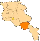
| Country | Armenia |
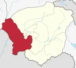
| Province | Vayots Dzor |
| Formed | 9 June 2017 |
| Administrative centre | Areni |
| Government | |
| • Mayor | Husik Sahakyan |
| Area | |
| • Total | 438 km2 (169 sq mi) |
| Population (2011 census) | |
| • Total | 10,410 |
| • Density | 24/km2 (62/sq mi) |
| Time zone | AMT (UTC+04) |
| Postal code | 3601–3810 |
| ISO 3166 code | AM-VD |
| FIPS 10-4 | AM10 |
Areni Municipality, referred to as Areni Community (Armenian: Արենի Համայնք Areni Hamaynk), is a rural community and administrative subdivision of Vayots Dzor Province of Armenia, at the southeast of the country. Consisted of a group of settlements, its administrative centre is the village of Areni.[1]
Included settlements
| Settlement | Type | Population (2011 census)[2] |
|---|---|---|
| Areni | Village, administrative centre | 1,772 |
| Agarakadzor | Village | 1,301 |
| Aghavnadzor | Village | 1,890 |
| Arpi | Village | 1,149 |
| Chiva | Village | 698 |
| Gnishik | Village | 44 |
| Khachik | Village | 862 |
| Mozrov | Village | 88 |
| Rind | Village | 1,397 |
| Yelpin | Village | 1,209 |
| Amaghu | Abandoned village | 0 |
References
This article is issued from Wikipedia. The text is licensed under Creative Commons - Attribution - Sharealike. Additional terms may apply for the media files.