Barbaste | |
|---|---|
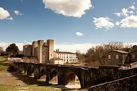 The bridge and the fortified mill in Barbaste | |
.svg.png.webp) Coat of arms | |
Location of Barbaste | |
 Barbaste  Barbaste | |
| Coordinates: 44°10′12″N 0°17′14″E / 44.17°N 0.2872°E | |
| Country | France |
| Region | Nouvelle-Aquitaine |
| Department | Lot-et-Garonne |
| Arrondissement | Nérac |
| Canton | Lavardac |
| Government | |
| • Mayor (2020–2026) | Valérie Tonin[1] |
| Area 1 | 38.7 km2 (14.9 sq mi) |
| Population | 1,493 |
| • Density | 39/km2 (100/sq mi) |
| Time zone | UTC+01:00 (CET) |
| • Summer (DST) | UTC+02:00 (CEST) |
| INSEE/Postal code | 47021 /47230 |
| Elevation | 38–146 m (125–479 ft) (avg. 126 m or 413 ft) |
| 1 French Land Register data, which excludes lakes, ponds, glaciers > 1 km2 (0.386 sq mi or 247 acres) and river estuaries. | |
Barbaste (French pronunciation: [baʁbast]; Occitan: Barbasta) is a commune in the Lot-et-Garonne department in southwestern France.
Population
| Year | Pop. | ±% p.a. |
|---|---|---|
| 1968 | 1,354 | — |
| 1975 | 1,373 | +0.20% |
| 1982 | 1,316 | −0.60% |
| 1990 | 1,354 | +0.36% |
| 1999 | 1,416 | +0.50% |
| 2009 | 1,494 | +0.54% |
| 2014 | 1,502 | +0.11% |
| 2020 | 1,501 | −0.01% |
| Source: INSEE[3] | ||
See also
References
- ↑ "Répertoire national des élus: les maires". data.gouv.fr, Plateforme ouverte des données publiques françaises (in French). 9 August 2021.
- ↑ "Populations légales 2021". The National Institute of Statistics and Economic Studies. 28 December 2023.
- ↑ Population en historique depuis 1968, INSEE
Wikimedia Commons has media related to Barbaste.
This article is issued from Wikipedia. The text is licensed under Creative Commons - Attribution - Sharealike. Additional terms may apply for the media files.