Bruguières | |
|---|---|
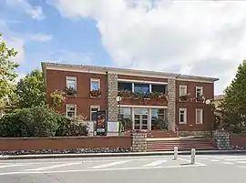 The town hall in Bruguières | |
.svg.png.webp) Coat of arms | |
Location of Bruguières | |
 Bruguières  Bruguières | |
| Coordinates: 43°43′30″N 1°24′44″E / 43.725°N 1.4122°E | |
| Country | France |
| Region | Occitania |
| Department | Haute-Garonne |
| Arrondissement | Toulouse |
| Canton | Castelginest |
| Intercommunality | Toulouse Métropole |
| Government | |
| • Mayor (2020–2026) | Philippe Plantade[1] |
| Area 1 | 9.03 km2 (3.49 sq mi) |
| Population | 5,957 |
| • Density | 660/km2 (1,700/sq mi) |
| Time zone | UTC+01:00 (CET) |
| • Summer (DST) | UTC+02:00 (CEST) |
| INSEE/Postal code | 31091 /31150 |
| Elevation | 116–175 m (381–574 ft) (avg. 130 m or 430 ft) |
| 1 French Land Register data, which excludes lakes, ponds, glaciers > 1 km2 (0.386 sq mi or 247 acres) and river estuaries. | |
Bruguières (French pronunciation: [bʁyɡjɛʁ]; Occitan: Bruguièras) is a commune of the Haute-Garonne department in southwestern France.
Population
| Year | Pop. | ±% p.a. |
|---|---|---|
| 1968 | 1,169 | — |
| 1975 | 1,726 | +5.72% |
| 1982 | 2,524 | +5.58% |
| 1990 | 3,056 | +2.42% |
| 1999 | 3,862 | +2.63% |
| 2007 | 4,923 | +3.08% |
| 2012 | 5,026 | +0.41% |
| 2017 | 5,832 | +3.02% |
| Source: INSEE[3] | ||
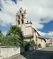 Église Saint-Martin
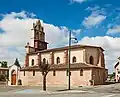 Église Saint-Martin
Twin town
See also
References
- ↑ "Répertoire national des élus: les maires". data.gouv.fr, Plateforme ouverte des données publiques françaises (in French). 2 December 2020.
- ↑ "Populations légales 2021". The National Institute of Statistics and Economic Studies. 28 December 2023.
- ↑ Population en historique depuis 1968, INSEE
- ↑ "Hermanamiento" [Twin town] (in Spanish). Ajuntament de Xeraco. 2023. p. 1. Retrieved 30 January 2023.
Wikimedia Commons has media related to Bruguières.
This article is issued from Wikipedia. The text is licensed under Creative Commons - Attribution - Sharealike. Additional terms may apply for the media files.