Clef Vallée d'Eure | |
|---|---|
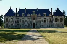 The chateau of La Croix-Saint-Leufroy | |
Location of Clef Vallée d'Eure | |
 Clef Vallée d'Eure  Clef Vallée d'Eure | |
| Coordinates: 49°06′32″N 1°14′35″E / 49.109°N 1.243°E | |
| Country | France |
| Region | Normandy |
| Department | Eure |
| Arrondissement | Les Andelys |
| Canton | Gaillon |
| Intercommunality | CA Seine-Eure |
| Government | |
| • Mayor (2020–2026) | Christophe Chambon[1] |
| Area 1 | 25.59 km2 (9.88 sq mi) |
| Population | 2,468 |
| • Density | 96/km2 (250/sq mi) |
| Time zone | UTC+01:00 (CET) |
| • Summer (DST) | UTC+02:00 (CEST) |
| INSEE/Postal code | 27191 /27490 |
| 1 French Land Register data, which excludes lakes, ponds, glaciers > 1 km2 (0.386 sq mi or 247 acres) and river estuaries. | |
Clef Vallée d'Eure (French pronunciation: [kle vale dœʁ]) is a commune in the department of Eure, northern France. The municipality was established on 1 January 2016 by merger of the former communes of La Croix-Saint-Leufroy, Écardenville-sur-Eure and Fontaine-Heudebourg.[3]
Population
| Year | Pop. | ±% p.a. |
|---|---|---|
| 1968 | 1,174 | — |
| 1975 | 1,245 | +0.84% |
| 1982 | 1,685 | +4.42% |
| 1990 | 1,864 | +1.27% |
| 1999 | 2,108 | +1.38% |
| 2007 | 2,254 | +0.84% |
| 2012 | 2,376 | +1.06% |
| 2017 | 2,533 | +1.29% |
| Source: INSEE[4] | ||
See also
References
Wikimedia Commons has media related to Clef Vallée d'Eure.
- ↑ "Répertoire national des élus: les maires" (in French). data.gouv.fr, Plateforme ouverte des données publiques françaises. 6 June 2023.
- ↑ "Populations légales 2021". The National Institute of Statistics and Economic Studies. 28 December 2023.
- ↑ Arrêté préfectoral 4 December 2015 (in French)
- ↑ Population en historique depuis 1968, INSEE
This article is issued from Wikipedia. The text is licensed under Creative Commons - Attribution - Sharealike. Additional terms may apply for the media files.