Drachkov | |
|---|---|
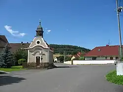 Centre of Drachkov | |
 Flag  Coat of arms | |
 Drachkov Location in the Czech Republic | |
| Coordinates: 49°14′34″N 13°50′30″E / 49.24278°N 13.84167°E | |
| Country | |
| Region | South Bohemian |
| District | Strakonice |
| First mentioned | 1319 |
| Area | |
| • Total | 3.39 km2 (1.31 sq mi) |
| Elevation | 450 m (1,480 ft) |
| Population (2023-01-01)[1] | |
| • Total | 203 |
| • Density | 60/km2 (160/sq mi) |
| Time zone | UTC+1 (CET) |
| • Summer (DST) | UTC+2 (CEST) |
| Postal code | 386 01 |
| Website | www |
Drachkov is a municipality and village in Strakonice District in the South Bohemian Region of the Czech Republic. It has about 200 inhabitants.
Drachkov lies approximately 6 kilometres (4 mi) south-west of Strakonice, 56 km (35 mi) north-west of České Budějovice, and 103 km (64 mi) south-west of Prague.
References
Wikimedia Commons has media related to Drachkov.
This article is issued from Wikipedia. The text is licensed under Creative Commons - Attribution - Sharealike. Additional terms may apply for the media files.