Krty-Hradec | |
|---|---|
.jpg.webp) Centre with chapel | |
 Flag  Coat of arms | |
 Krty-Hradec Location in the Czech Republic | |
| Coordinates: 49°17′29″N 13°50′53″E / 49.29139°N 13.84806°E | |
| Country | |
| Region | South Bohemian |
| District | Strakonice |
| First mentioned | 1227 |
| Area | |
| • Total | 4.94 km2 (1.91 sq mi) |
| Elevation | 431 m (1,414 ft) |
| Population (2023-01-01)[1] | |
| • Total | 130 |
| • Density | 26/km2 (68/sq mi) |
| Time zone | UTC+1 (CET) |
| • Summer (DST) | UTC+2 (CEST) |
| Postal code | 387 11 |
| Website | krtyhradec |
Krty-Hradec is a municipality and village in Strakonice District in the South Bohemian Region of the Czech Republic. It has about 100 inhabitants.
Krty-Hradec lies approximately 6 kilometres (4 mi) north-west of Strakonice, 58 km (36 mi) north-west of České Budějovice, and 98 km (61 mi) south-west of Prague.
Gallery
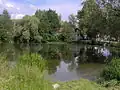 Veský Pond
.jpg.webp) Fire station
Fire station.jpg.webp) A street
A street
References
Wikimedia Commons has media related to Krty-Hradec.
This article is issued from Wikipedia. The text is licensed under Creative Commons - Attribution - Sharealike. Additional terms may apply for the media files.