Finkenberg | |
|---|---|
 | |
 Coat of arms | |
 Finkenberg Location within Austria | |
| Coordinates: 47°09′10″N 11°49′18″E / 47.15278°N 11.82167°E | |
| Country | Austria |
| State | Tyrol |
| District | Schwaz |
| Government | |
| • Mayor | Mathias Eberl |
| Area | |
| • Total | 171.54 km2 (66.23 sq mi) |
| Elevation | 839 m (2,753 ft) |
| Population (2018-01-01)[2] | |
| • Total | 1,421 |
| • Density | 8.3/km2 (21/sq mi) |
| Time zone | UTC+1 (CET) |
| • Summer (DST) | UTC+2 (CEST) |
| Postal code | 6292 |
| Area code | 05285 |
| Vehicle registration | SZ |
| Website | www.finkenberg. tirol.gv.at |
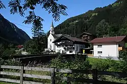
Finkenberg is a municipality in the Schwaz district in the Austrian state of Tyrol.
Geography
Finkenberg lies about 3 km southwest of Mayrhofen at the entrance to the Tuxer valley.
Sightseeing
- Garnet Chapel near the Penken.
References
- ↑ "Dauersiedlungsraum der Gemeinden Politischen Bezirke und Bundesländer - Gebietsstand 1.1.2018". Statistics Austria. Retrieved 10 March 2019.
- ↑ "Einwohnerzahl 1.1.2018 nach Gemeinden mit Status, Gebietsstand 1.1.2018". Statistics Austria. Retrieved 9 March 2019.
Wikimedia Commons has media related to Finkenberg.
Wikivoyage has a travel guide for Finkenberg.
This article is issued from Wikipedia. The text is licensed under Creative Commons - Attribution - Sharealike. Additional terms may apply for the media files.