Hart im Zillertal | |
|---|---|
 | |
 Coat of arms | |
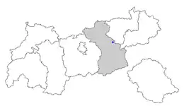 Location within Tyrol | |
 Hart im Zillertal Location within Austria | |
| Coordinates: 47°21′00″N 11°52′00″E / 47.35000°N 11.86667°E | |
| Country | Austria |
| State | Tyrol |
| District | Schwaz |
| Government | |
| • Mayor | Alois Eberharter (ÖVP) |
| Area | |
| • Total | 35.54 km2 (13.72 sq mi) |
| Elevation | 666 m (2,185 ft) |
| Population (2018-01-01)[2] | |
| • Total | 1,587 |
| • Density | 45/km2 (120/sq mi) |
| Time zone | UTC+1 (CET) |
| • Summer (DST) | UTC+2 (CEST) |
| Postal code | 6263 |
| Area code | 05288 |
| Vehicle registration | SZ |
Hart im Zillertal is a municipality in the Schwaz district in the Austrian state of Tyrol.
Geography
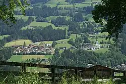
Hart lies across from Fügen on the east side of the Ziller.
References
- ↑ "Dauersiedlungsraum der Gemeinden Politischen Bezirke und Bundesländer - Gebietsstand 1.1.2018". Statistics Austria. Retrieved 10 March 2019.
- ↑ "Einwohnerzahl 1.1.2018 nach Gemeinden mit Status, Gebietsstand 1.1.2018". Statistics Austria. Retrieved 9 March 2019.
Wikimedia Commons has media related to Hart im Zillertal.
This article is issued from Wikipedia. The text is licensed under Creative Commons - Attribution - Sharealike. Additional terms may apply for the media files.