Gaillard | |
|---|---|
 Flag .svg.png.webp) Coat of arms | |
Location of Gaillard | |
 Gaillard  Gaillard | |
| Coordinates: 46°11′09″N 6°12′30″E / 46.1858°N 6.2083°E | |
| Country | France |
| Region | Auvergne-Rhône-Alpes |
| Department | Haute-Savoie |
| Arrondissement | Saint-Julien-en-Genevois |
| Canton | Gaillard |
| Intercommunality | Annemasse – Les Voirons |
| Government | |
| • Mayor (2023–2026) | Antoine Blouin[1] |
| Area 1 | 4.02 km2 (1.55 sq mi) |
| Population | 10,175 |
| • Density | 2,500/km2 (6,600/sq mi) |
| Time zone | UTC+01:00 (CET) |
| • Summer (DST) | UTC+02:00 (CEST) |
| INSEE/Postal code | 74133 /74240 |
| Elevation | 392–425 m (1,286–1,394 ft) (avg. 420 m or 1,380 ft) |
| 1 French Land Register data, which excludes lakes, ponds, glaciers > 1 km2 (0.386 sq mi or 247 acres) and river estuaries. | |
Gaillard (French pronunciation: [ɡajaʁ] ⓘ) is a commune in the Haute-Savoie department in the Auvergne-Rhône-Alpes region in south-eastern France.
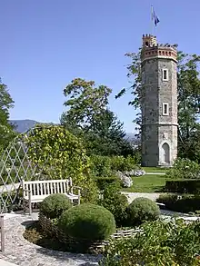
Roseraie et Tour de Naz
Gaillard lies on the border with Switzerland, 5 km east of the city centre of Geneva. The biggest border crossing is called Moillesulaz and the second one is Fossard.
Population
| Year | Pop. | ±% p.a. |
|---|---|---|
| 1968 | 6,233 | — |
| 1975 | 9,027 | +5.43% |
| 1982 | 9,079 | +0.08% |
| 1990 | 9,592 | +0.69% |
| 1999 | 9,949 | +0.41% |
| 2007 | 11,397 | +1.71% |
| 2012 | 11,303 | −0.17% |
| 2017 | 10,619 | −1.24% |
| Source: INSEE[3] | ||
See also
References
- ↑ "Répertoire national des élus: les maires" (in French). data.gouv.fr, Plateforme ouverte des données publiques françaises. 6 June 2023.
- ↑ "Populations légales 2021". The National Institute of Statistics and Economic Studies. 28 December 2023.
- ↑ Population en historique depuis 1968, INSEE
External links
Wikimedia Commons has media related to Gaillard (Haute-Savoie).
This article is issued from Wikipedia. The text is licensed under Creative Commons - Attribution - Sharealike. Additional terms may apply for the media files.