Saint-Jeoire | |
|---|---|
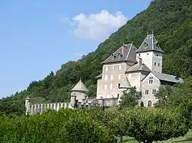 The Beauregard Castle, which looms over the village | |
Location of Saint-Jeoire | |
 Saint-Jeoire  Saint-Jeoire | |
| Coordinates: 46°08′20″N 6°27′36″E / 46.1389°N 6.46°E | |
| Country | France |
| Region | Auvergne-Rhône-Alpes |
| Department | Haute-Savoie |
| Arrondissement | Bonneville |
| Canton | Bonneville |
| Government | |
| • Mayor (2020–2026) | Antoine Valentin[1] |
| Area 1 | 22.75 km2 (8.78 sq mi) |
| Population | 3,431 |
| • Density | 150/km2 (390/sq mi) |
| Demonym | Saint-Jeoiriens |
| Time zone | UTC+01:00 (CET) |
| • Summer (DST) | UTC+02:00 (CEST) |
| INSEE/Postal code | 74241 /74490 |
| Elevation | 498–1,863 m (1,634–6,112 ft) |
| Website | www.saint-jeoire.fr |
| 1 French Land Register data, which excludes lakes, ponds, glaciers > 1 km2 (0.386 sq mi or 247 acres) and river estuaries. | |
Saint-Jeoire (French pronunciation: [sɛ̃ ʒwaʁ]; Arpitan: San Zhouro) is a commune in the Haute-Savoie department in the Auvergne-Rhône-Alpes region in south-eastern France.
Population
| Year | Pop. | ±% p.a. |
|---|---|---|
| 1968 | 1,876 | — |
| 1975 | 1,865 | −0.08% |
| 1982 | 1,896 | +0.24% |
| 1990 | 2,209 | +1.93% |
| 1999 | 2,749 | +2.46% |
| 2007 | 3,112 | +1.56% |
| 2012 | 3,212 | +0.63% |
| 2017 | 3,282 | +0.43% |
| Source: INSEE[3] | ||
See also
References
- ↑ "Répertoire national des élus: les maires". data.gouv.fr, Plateforme ouverte des données publiques françaises (in French). 9 August 2021.
- ↑ "Populations légales 2021". The National Institute of Statistics and Economic Studies. 28 December 2023.
- ↑ Population en historique depuis 1968, INSEE
Wikimedia Commons has media related to Saint-Jeoire.
This article is issued from Wikipedia. The text is licensed under Creative Commons - Attribution - Sharealike. Additional terms may apply for the media files.