Grafengehaig | |
|---|---|
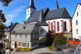 Fortified church of the Holy Spirit in Grafengehaig | |
 Coat of arms | |
Location of Grafengehaig within Kulmbach district 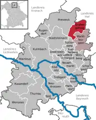 | |
 Grafengehaig  Grafengehaig | |
| Coordinates: 50°12′N 11°34′E / 50.200°N 11.567°E | |
| Country | Germany |
| State | Bavaria |
| Admin. region | Oberfranken |
| District | Kulmbach |
| Municipal assoc. | Marktleugast |
| Subdivisions | 27 Ortsteile |
| Government | |
| • Mayor (2020–26) | Werner Burger[1] |
| Area | |
| • Total | 20.80 km2 (8.03 sq mi) |
| Elevation | 568 m (1,864 ft) |
| Population (2022-12-31)[2] | |
| • Total | 834 |
| • Density | 40/km2 (100/sq mi) |
| Time zone | UTC+01:00 (CET) |
| • Summer (DST) | UTC+02:00 (CEST) |
| Postal codes | 95356 |
| Dialling codes | 09255 |
| Vehicle registration | KU |
| Website | https://www.grafengehaig.de/ |
Grafengehaig is a municipality in the district of Kulmbach in Bavaria in Germany.
It is a part of the Franconian Forest nature park.
City arrangement
Grafengehaig is arranged in the following boroughs:
|
|
References
- ↑ Liste der ersten Bürgermeister/Oberbürgermeister in kreisangehörigen Gemeinden, Bayerisches Landesamt für Statistik, 15 July 2021.
- ↑ Genesis Online-Datenbank des Bayerischen Landesamtes für Statistik Tabelle 12411-003r Fortschreibung des Bevölkerungsstandes: Gemeinden, Stichtag (Einwohnerzahlen auf Grundlage des Zensus 2011)
Wikimedia Commons has media related to Grafengehaig.
Towns and municipalities in Kulmbach (district) | ||
|---|---|---|
This article is issued from Wikipedia. The text is licensed under Creative Commons - Attribution - Sharealike. Additional terms may apply for the media files.