Hodice | |
|---|---|
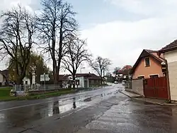 Centre of Hodice | |
 Flag  Coat of arms | |
 Hodice Location in the Czech Republic | |
| Coordinates: 49°16′12″N 15°28′48″E / 49.27000°N 15.48000°E | |
| Country | |
| Region | Vysočina |
| District | Jihlava |
| First mentioned | 1303 |
| Area | |
| • Total | 12.54 km2 (4.84 sq mi) |
| Elevation | 563 m (1,847 ft) |
| Population (2023-01-01)[1] | |
| • Total | 715 |
| • Density | 57/km2 (150/sq mi) |
| Time zone | UTC+1 (CET) |
| • Summer (DST) | UTC+2 (CEST) |
| Postal code | 589 01 |
| Website | www |
Hodice (Czech pronunciation: [ˈɦoɟɪtsɛ]; German: Höditz) is a municipality and village in Jihlava District in the Vysočina Region of the Czech Republic. It has about 700 inhabitants.
Hodice lies approximately 18 kilometres (11 mi) south-west of Jihlava and 119 km (74 mi) south-east of Prague.
References
Wikimedia Commons has media related to Hodice.
This article is issued from Wikipedia. The text is licensed under Creative Commons - Attribution - Sharealike. Additional terms may apply for the media files.