40°16′23″N 45°08′40″E / 40.27306°N 45.14444°E
Lanjaghbyur
Լանջաղբյուր | |
|---|---|
.jpg.webp) A view of Lanjaghbyur and Ilikavank Monastery | |
 Lanjaghbyur  Lanjaghbyur | |
| Coordinates: 40°16′23″N 45°08′40″E / 40.27306°N 45.14444°E | |
| Country | Armenia |
| Province | Gegharkunik |
| Municipality | Gavar |
| Founded | 1828 |
| Population | |
| • Total | 2,115 |
| Time zone | UTC+4 (AMT) |
| Lanjaghbyur at GEOnet Names Server | |
Lanjaghbyur (Armenian: Լանջաղբյուր) is a village in the Gavar Municipality of the Gegharkunik Province of Armenia.
History
The village was founded in 1828.
Gallery
.jpg.webp) A view of Lanjaghbyur from Surb Khach Church
A view of Lanjaghbyur from Surb Khach Church.jpg.webp) Surb Khach Church
Surb Khach Church.jpg.webp) Surb Khach Church
Surb Khach Church.jpg.webp) Ilikavank Monastery
Ilikavank Monastery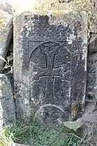 Khachkar near St. Hakob Church
References
External links
Wikimedia Commons has media related to Cultural heritage monuments in Lanjaghbyur, Gegharkunik.
- Report of the results of the 2001 Armenian Census, Statistical Committee of Armenia
- Kiesling, Brady (2005), Rediscovering Armenia: Guide, Yerevan, Armenia: Matit Graphic Design Studio
- Kiesling, Brady (June 2000). Rediscovering Armenia: An Archaeological/Touristic Gazetteer and Map Set for the Historical Monuments of Armenia (PDF). Archived (PDF) from the original on 6 November 2021.
This article is issued from Wikipedia. The text is licensed under Creative Commons - Attribution - Sharealike. Additional terms may apply for the media files.