Pereto | |
|---|---|
| Comune di Pereto | |
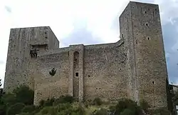 Medieval castle in Pereto | |
Location of Pereto | |
 Pereto Location of Pereto in Italy 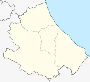 Pereto Pereto (Abruzzo) | |
| Coordinates: 42°02′36″N 13°06′08″E / 42.04333°N 13.10222°E | |
| Country | Italy |
| Region | Abruzzo |
| Province | L'Aquila (AQ) |
| Area | |
| • Total | 41.05 km2 (15.85 sq mi) |
| Elevation | 800 m (2,600 ft) |
| Population (2005)[2] | |
| • Total | 721 |
| • Density | 18/km2 (45/sq mi) |
| Demonym | Peretani |
| Time zone | UTC+1 (CET) |
| • Summer (DST) | UTC+2 (CEST) |
| Postal code | 67064 |
| Dialing code | 0863 |
| Patron saint | St. George |
| Saint day | 23 April |
Pereto (Marsicano: Pirìtu) is a comune and town in the province of L'Aquila in the Abruzzo region of Italy.
It was an ancient centre of the Marsi.
Main sights
- Medieval castle, with its 13th-century imposing towers, which belonged to the Colonna family from the late 15th century.
- Sanctuary of Madonna dei Bisognosi: According to the local tradition, it was erected in 608 AD. It houses some notable late-15th-century frescoes and a Crucifix carried here by Pope Boniface IV for the church's consecration.
Outside the hamlet is the Church of Santa Maria in Cellis (1132).
References
- ↑ "Superficie di Comuni Province e Regioni italiane al 9 ottobre 2011". Italian National Institute of Statistics. Retrieved 16 March 2019.
- ↑ "Popolazione Residente al 1° Gennaio 2018". Italian National Institute of Statistics. Retrieved 16 March 2019.
This article is issued from Wikipedia. The text is licensed under Creative Commons - Attribution - Sharealike. Additional terms may apply for the media files.