 | |
|---|---|
| Bóthar R283 | |
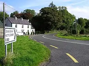 R283 at Moneenshinnagh | |
| Route information | |
| Length | 10.7 km (6.6 mi) |
| Major junctions | |
| From | |
| To | Border with Northern Ireland |
| Location | |
| Country | Ireland |
| Highway system | |
The R283 road is a regional road in Ireland, located in County Leitrim.[1][2]
References
- ↑ "R283 - Roader's Digest: The SABRE Wiki". www.sabre-roads.org.uk.
- ↑ Book (eISB), electronic Irish Statute. "electronic Irish Statute Book (eISB)". www.irishstatutebook.ie.
54°21′15″N 8°02′19″W / 54.354294°N 8.038489°W
This article is issued from Wikipedia. The text is licensed under Creative Commons - Attribution - Sharealike. Additional terms may apply for the media files.