Saint-Ciers-Champagne | |
|---|---|
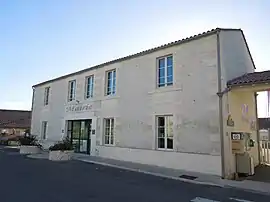 The town hall in Saint-Ciers-Champagne | |
Location of Saint-Ciers-Champagne | |
 Saint-Ciers-Champagne  Saint-Ciers-Champagne | |
| Coordinates: 45°26′37″N 0°17′53″W / 45.4436°N 0.2981°W | |
| Country | France |
| Region | Nouvelle-Aquitaine |
| Department | Charente-Maritime |
| Arrondissement | Jonzac |
| Canton | Jonzac |
| Government | |
| • Mayor (2020–2026) | Michel Vion[1] |
| Area 1 | 18.08 km2 (6.98 sq mi) |
| Population | 387 |
| • Density | 21/km2 (55/sq mi) |
| Time zone | UTC+01:00 (CET) |
| • Summer (DST) | UTC+02:00 (CEST) |
| INSEE/Postal code | 17316 /17520 |
| Elevation | 38–118 m (125–387 ft) (avg. 49 m or 161 ft) |
| 1 French Land Register data, which excludes lakes, ponds, glaciers > 1 km2 (0.386 sq mi or 247 acres) and river estuaries. | |
Saint-Ciers-Champagne (French pronunciation: [sɛ̃ sje ʃɑ̃paɲ]) is a commune in the Charente-Maritime department in the Nouvelle-Aquitaine region in southwestern France.
Population
| Year | Pop. | ±% |
|---|---|---|
| 1962 | 434 | — |
| 1968 | 501 | +15.4% |
| 1975 | 406 | −19.0% |
| 1982 | 382 | −5.9% |
| 1990 | 376 | −1.6% |
| 1999 | 357 | −5.1% |
| 2008 | 381 | +6.7% |
See also
References
- ↑ "Répertoire national des élus: les maires". data.gouv.fr, Plateforme ouverte des données publiques françaises (in French). 9 August 2021.
- ↑ "Populations légales 2021". The National Institute of Statistics and Economic Studies. 28 December 2023.
External links
 Media related to Saint-Ciers-Champagne at Wikimedia Commons
This article is issued from Wikipedia. The text is licensed under Creative Commons - Attribution - Sharealike. Additional terms may apply for the media files.