Saint-Mard | |
|---|---|
 The town hall of Saint-Mard | |
.svg.png.webp) Coat of arms | |
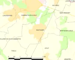 | |
Location of Saint-Mard | |
 Saint-Mard  Saint-Mard | |
| Coordinates: 49°02′12″N 2°41′38″E / 49.0366°N 2.6939°E | |
| Country | France |
| Region | Île-de-France |
| Department | Seine-et-Marne |
| Arrondissement | Meaux |
| Canton | Mitry-Mory |
| Intercommunality | CA Roissy Pays de France |
| Government | |
| • Mayor (2020–2026) | Daniel Dometz[1] |
| Area 1 | 6.26 km2 (2.42 sq mi) |
| Population | 3,847 |
| • Density | 610/km2 (1,600/sq mi) |
| Time zone | UTC+01:00 (CET) |
| • Summer (DST) | UTC+02:00 (CEST) |
| INSEE/Postal code | 77420 /77230 |
| Elevation | 93–166 m (305–545 ft) |
| 1 French Land Register data, which excludes lakes, ponds, glaciers > 1 km2 (0.386 sq mi or 247 acres) and river estuaries. | |
Saint-Mard (French pronunciation: [sɛ̃ maʁ] ⓘ) is a commune in the Seine-et-Marne department in the Île-de-France region in north-central France.
Population
| Year | Pop. | ±% p.a. |
|---|---|---|
| 1968 | 1,090 | — |
| 1975 | 2,021 | +9.22% |
| 1982 | 2,375 | +2.33% |
| 1990 | 2,959 | +2.79% |
| 1999 | 3,445 | +1.70% |
| 2007 | 3,663 | +0.77% |
| 2012 | 3,849 | +1.00% |
| 2017 | 3,857 | +0.04% |
| Source: INSEE[3] | ||
Inhabitants of Saint-Mard are called Mardochiens in French.
See also
References
- ↑ "Répertoire national des élus: les maires" (in French). data.gouv.fr, Plateforme ouverte des données publiques françaises. 13 September 2022.
- ↑ "Populations légales 2021". The National Institute of Statistics and Economic Studies. 28 December 2023.
- ↑ Population en historique depuis 1968, INSEE
External links
Wikimedia Commons has media related to Saint-Mard (Seine-et-Marne).
- 1999 Land Use, from IAURIF (Institute for Urban Planning and Development of the Paris-Île-de-France région) (in English)
This article is issued from Wikipedia. The text is licensed under Creative Commons - Attribution - Sharealike. Additional terms may apply for the media files.