Saint-Mesmes | |
|---|---|
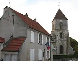 The town hall of Saint-Mesmes and the church Saint-Maxime | |
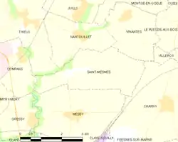 | |
Location of Saint-Mesmes | |
 Saint-Mesmes  Saint-Mesmes | |
| Coordinates: 48°59′00″N 2°42′00″E / 48.9833°N 2.700000°E | |
| Country | France |
| Region | Île-de-France |
| Department | Seine-et-Marne |
| Arrondissement | Meaux |
| Canton | Claye-Souilly |
| Intercommunality | CC Plaines et Monts de France |
| Government | |
| • Mayor (2020–2026) | Alfred Stadler[1] |
| Area 1 | 7.69 km2 (2.97 sq mi) |
| Population | 613 |
| • Density | 80/km2 (210/sq mi) |
| Time zone | UTC+01:00 (CET) |
| • Summer (DST) | UTC+02:00 (CEST) |
| INSEE/Postal code | 77427 /77410 |
| Elevation | 57–118 m (187–387 ft) |
| 1 French Land Register data, which excludes lakes, ponds, glaciers > 1 km2 (0.386 sq mi or 247 acres) and river estuaries. | |
Saint-Mesmes (French pronunciation: [sɛ̃ mɛm] ⓘ) is a commune in the Seine-et-Marne department in the Île-de-France region in north-central France.
Demographics
Inhabitants of Saint-Mesmes are called Maximois.
See also
References
- ↑ "Répertoire national des élus: les maires" (in French). data.gouv.fr, Plateforme ouverte des données publiques françaises. 13 September 2022.
- ↑ "Populations légales 2021". The National Institute of Statistics and Economic Studies. 28 December 2023.
External links
Wikimedia Commons has media related to Saint-Mesmes.
- 1999 Land Use, from IAURIF (Institute for Urban Planning and Development of the Paris-Île-de-France région) (in English)
- Base Mérimée: Search for heritage in the commune, Ministère français de la Culture. (in French)
This article is issued from Wikipedia. The text is licensed under Creative Commons - Attribution - Sharealike. Additional terms may apply for the media files.