Shivgarh | |
|---|---|
Village | |
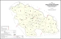 Map of Shivgarh CD block | |
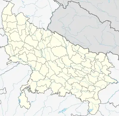 Shivgarh Location in Uttar Pradesh, India | |
| Coordinates: 26°32′30″N 81°15′02″E / 26.541677°N 81.250506°E[1] | |
| Country India | |
| State | Uttar Pradesh |
| District | Raebareli |
| Area | |
| • Total | 1.56 km2 (0.60 sq mi) |
| Population (2011)[2] | |
| • Total | 2,812 |
| • Density | 1,800/km2 (4,700/sq mi) |
| Languages | |
| • Official | Hindi |
| Time zone | UTC+5:30 (IST) |
| PIN | 229308[2] |
| Vehicle registration | UP-33 |
Shivgarh is a Nagar Panchayat (Town Panchayat; transl. 'town council') or Notified Area Council (NAC) in Rae Bareli district, Uttar Pradesh, India.[2] As of 2011, its population is 2,812, in 536 households.[2] It has 6 primary schools and 1 healthcare centre.[2] It hosts a Ramlila festival on Agrahayana Sudi 5-11, which involves a dramatic reenactment of the Ramayana.[3] Vendors bring farm tools, earthenware pots, bamboo baskets, toys, and sweets to sell at the festival.[3] Shivgarh also hosts market weekly twice, on Thursdays and Sundays, which mostly deals in grain and kirana.[3]
The 1961 census recorded Shivgarh (here spelled "Sheogarh") as comprising 4 hamlets, with a total population of 952 people (475 male and 429 female), in 212 households and 175 physical houses.[3] The area of the village was given as 395 acres.[3] It had a hospital with 8 beds for males and 6 for females, and it was run by a local body at the time.[3] The Barkhandi Vidyapeeth in Sheogarh, a higher secondary school founded in 1950, had in 1961 a faculty of 23 teachers (all male) and a student body of 451 males and 8 females.[3] Average attendance of the Ramlila festival was recorded as about 3,000 people, while attendance of the twice-weekly market was about 300.[3]
The 1981 census recorded Shivgarh (here also spelled as "Sheogarh") as having a population of 1,588 people, in 351 households, and having an area of 159.86 hectares.[4]
The most busiest route in this town is Shivgarh Main Market route and best English medium School " M.P. Educational Academy" for students to gain knowledge
Mallu ka purva
Shivgarh CD block has the following 62 villages:[2]
| Village name | Total land area (hectares) | Population (in 2011) |
|---|---|---|
| Mawaiya | 288.8 | 898 |
| Pindauli | 355.4 | 2,094 |
| Bahuda Khurd | 123.6 | 1,852 |
| Bahuda Kalan | 250.2 | 988 |
| Deheli | 710.2 | 4,109 |
| Chitwaniya | 329.1 | 2,314 |
| Bedaru | 1,128.2 | 4,924 |
| Banka Garh | 375.1 | 1,576 |
| Surajpur, Raebareli | 295.8 | 2,018 |
| Baiti | 595.8 | 5,456 |
| Kumbhi | 446 | 3,547 |
| Dhekwa | 194 | 1,594 |
| Rampur Muligarha | 118 | 777 |
| Pipri | 102 | 1,263 |
| Sivli | 271 | 3,366 |
| Dahigawan | 544.1 | 4,230 |
| Math Goshaee | 29.1 | 471 |
| Masapur | 78.1 | 418 |
| Kumharawan | 296.6 | 2,441 |
| Badaver | 186 | 1,037 |
| Kasna | 135.2 | 1,191 |
| Rajapur | 53.2 | 767 |
| Shergarh | 77.4 | 548 |
| Padariya | 173.3 | 869 |
| Jaraw Ganj | 303.1 | 2,100 |
| Rani Khera | 58 | 368 |
| Jugrajpur | 77.2 | 375 |
| Aimapur | 195 | 1,296 |
| Gumawan | 388.2 | 2,482 |
| Nerthuwa | 897 | 4,340 |
| Riwan | 552.6 | 3,220 |
| Variyarpur | 230.4 | 1,217 |
| Basantpur Sakatpur | 786 | 2,831 |
| Shahpur | 112 | 966 |
| Katkouli | 36.2 | 130 |
| Achhai | 591.2 | 2,652 |
| Raipur | 294 | 1,981 |
| Siwan | 926 | 3,437 |
| Rajapur Mustsil Siwan | 123 | 1,059 |
| Jamunipur | 103 | 402 |
| Kamalpur Awadih | 153.3 | 680 |
| Sarain Chhatradhari | 242 | 1,932 |
| Bhawani Garh | 633.2 | 3,770 |
| Dhodhawapur | 240.2 | 2,069 |
| Shiv Garh (block headquarters) | 156 | 2,812 |
| Rampur Khas | 163 | 1,386 |
| Bansinghpur | 43 | 72 |
| Natai | 34 | 345 |
| Kotwa | 307.2 | 1,613 |
| Niyat Kunwar Khera | 33 | 165 |
| Raipur Neruwa | 280.2 | 1,197 |
| Jagdishpur | 415 | 1,953 |
| Basant Kunwar Khera | 41 | 290 |
| Rampur Padumnath | 143 | 351 |
| Bhausi | 359.3 | 2,594 |
| Govindpur | 435.7 | 1,884 |
| Osah | 522 | 3,341 |
| Rampur Tikara | 137 | 973 |
| Bhawaniyapur | 57 | 134 |
| Narayanpur | 508.3 | 1,634 |
| Khajuron | 633.5 | 3,620 |
| Gurha | 1,377.9 | 6,432 |
References
- ↑ "GeoNames Search". geonames.nga.mil. Archived from the original on 12 April 2014. Retrieved 24 June 2023.
- 1 2 3 4 5 6 7 "Census of India 2011: Uttar Pradesh District Census Handbook - Rae Bareli, Part A (Village and Town Directory)" (PDF). Census 2011 India. pp. 91–107. Retrieved 25 July 2021.
- 1 2 3 4 5 6 7 8 Census 1961: District Census Handbook, Uttar Pradesh (39 - Raebareli District) (PDF). Lucknow. 1965. pp. 144, 147, 166–7, 173, xii-xiii of section "Maharajganj Tahsil". Retrieved 27 July 2021.
{{cite book}}: CS1 maint: location missing publisher (link) - ↑ Census 1981 Uttar Pradesh: District Census Handbook Part XIII-A: Village & Town Directory, District Rae Bareli (PDF). 1982. pp. 38–9. Retrieved 27 July 2021.