Auriac-du-Périgord | |
|---|---|
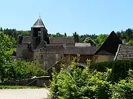 The church and surroundings in Auriac-du-Périgord | |
Location of Auriac-du-Périgord | |
 Auriac-du-Périgord  Auriac-du-Périgord | |
| Coordinates: 45°06′26″N 1°08′15″E / 45.1072°N 1.1375°E | |
| Country | France |
| Region | Nouvelle-Aquitaine |
| Department | Dordogne |
| Arrondissement | Sarlat-la-Canéda |
| Canton | Haut-Périgord Noir |
| Intercommunality | CC Terrassonnais Périgord Noir Thenon Hautefort |
| Government | |
| • Mayor (2020–2026) | Dominique Duruy[1] |
| Area 1 | 18.63 km2 (7.19 sq mi) |
| Population | 401 |
| • Density | 22/km2 (56/sq mi) |
| Time zone | UTC+01:00 (CET) |
| • Summer (DST) | UTC+02:00 (CEST) |
| INSEE/Postal code | 24018 /24290 |
| Elevation | 93–293 m (305–961 ft) (avg. 90 m or 300 ft) |
| 1 French Land Register data, which excludes lakes, ponds, glaciers > 1 km2 (0.386 sq mi or 247 acres) and river estuaries. | |
Auriac-du-Périgord (French pronunciation: [oʁjak dy peʁiɡɔʁ], literally Auriac of the Périgord; Occitan: Auriac de Perigòrd) is a commune in the Dordogne department in Nouvelle-Aquitaine in southwestern France.
Population
| Year | Pop. | ±% p.a. |
|---|---|---|
| 1968 | 338 | — |
| 1975 | 316 | −0.96% |
| 1982 | 333 | +0.75% |
| 1990 | 377 | +1.56% |
| 1999 | 398 | +0.60% |
| 2009 | 419 | +0.52% |
| 2014 | 388 | −1.53% |
| 2020 | 401 | +0.55% |
| Source: INSEE[3] | ||
See also
References
- ↑ "Répertoire national des élus: les maires". data.gouv.fr, Plateforme ouverte des données publiques françaises (in French). 2 December 2020.
- ↑ "Populations légales 2021". The National Institute of Statistics and Economic Studies. 28 December 2023.
- ↑ Population en historique depuis 1968, INSEE
Wikimedia Commons has media related to Auriac-du-Périgord.
This article is issued from Wikipedia. The text is licensed under Creative Commons - Attribution - Sharealike. Additional terms may apply for the media files.