Biron | |
|---|---|
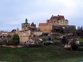 A general view of Biron | |
.svg.png.webp) Coat of arms | |
Location of Biron | |
 Biron  Biron | |
| Coordinates: 44°37′54″N 0°52′23″E / 44.6317°N 0.8731°E | |
| Country | France |
| Region | Nouvelle-Aquitaine |
| Department | Dordogne |
| Arrondissement | Bergerac |
| Canton | Lalinde |
| Government | |
| • Mayor (2020–2026) | Bruno Desmaison[1] |
| Area 1 | 12.98 km2 (5.01 sq mi) |
| Population | 140 |
| • Density | 11/km2 (28/sq mi) |
| Time zone | UTC+01:00 (CET) |
| • Summer (DST) | UTC+02:00 (CEST) |
| INSEE/Postal code | 24043 /24540 |
| Elevation | 128–240 m (420–787 ft) (avg. 200 m or 660 ft) |
| 1 French Land Register data, which excludes lakes, ponds, glaciers > 1 km2 (0.386 sq mi or 247 acres) and river estuaries. | |
Biron (French pronunciation: [biʁɔ̃]; Occitan: Biront) is a commune in the Dordogne department in southwestern France.
Geography
Biron lies between the Dropt and Lède rivers between the towns of Monpazier, Villeréal and Villefranche-du-Périgord.
Population
| Year | Pop. | ±% p.a. |
|---|---|---|
| 1968 | 123 | — |
| 1975 | 121 | −0.23% |
| 1982 | 120 | −0.12% |
| 1990 | 132 | +1.20% |
| 1999 | 140 | +0.66% |
| 2009 | 182 | +2.66% |
| 2014 | 190 | +0.86% |
| 2020 | 142 | −4.74% |
| Source: INSEE[3] | ||
Sights
Biron is dominated by the Château de Biron, which overlooks the village and was a bastion in medieval times. Today the château is a tourist hotspot in the summer months.
See also
References
- ↑ "Répertoire national des élus: les maires". data.gouv.fr, Plateforme ouverte des données publiques françaises (in French). 2 December 2020.
- ↑ "Populations légales 2021". The National Institute of Statistics and Economic Studies. 28 December 2023.
- ↑ Population en historique depuis 1968, INSEE
External links
Wikimedia Commons has media related to Biron (Dordogne).
This article is issued from Wikipedia. The text is licensed under Creative Commons - Attribution - Sharealike. Additional terms may apply for the media files.