Babice u Rosic | |
|---|---|
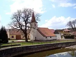 Centre with the Chapel of St. Anthony of Padua | |
 Flag  Coat of arms | |
 Babice u Rosic Location in the Czech Republic | |
| Coordinates: 49°10′23″N 16°21′29″E / 49.17306°N 16.35806°E | |
| Country | |
| Region | South Moravian |
| District | Brno-Country |
| First mentioned | 1104 |
| Area | |
| • Total | 5.69 km2 (2.20 sq mi) |
| Elevation | 370 m (1,210 ft) |
| Population (2023-01-01)[1] | |
| • Total | 789 |
| • Density | 140/km2 (360/sq mi) |
| Time zone | UTC+1 (CET) |
| • Summer (DST) | UTC+2 (CEST) |
| Postal codes | 664 84 |
| Website | www |
Babice u Rosic is a municipality and village in Brno-Country District in the South Moravian Region of the Czech Republic. It has about 800 inhabitants.
Demographics
| Year | Pop. | ±% |
|---|---|---|
| 1869 | 674 | — |
| 1880 | 652 | −3.3% |
| 1890 | 748 | +14.7% |
| 1900 | 788 | +5.3% |
| 1910 | 900 | +14.2% |
| 1921 | 968 | +7.6% |
| 1930 | 890 | −8.1% |
| 1950 | 808 | −9.2% |
| 1961 | 737 | −8.8% |
| 1970 | 646 | −12.3% |
| 1980 | 559 | −13.5% |
| 1991 | 474 | −15.2% |
| 2001 | 523 | +10.3% |
| 2011 | 659 | +26.0% |
| 2021 | 798 | +21.1% |
| Source: Censuses[2][3] | ||
References
- ↑ "Population of Municipalities – 1 January 2023". Czech Statistical Office. 2023-05-23.
- ↑ "Historický lexikon obcí České republiky 1869–2011 – Okres Brno-venkov" (in Czech). Czech Statistical Office. 2015-12-21.
- ↑ "Population Census 2021: Population by sex". Public Database. Czech Statistical Office. 2021-03-27.
External links
Wikimedia Commons has media related to Babice u Rosic.
This article is issued from Wikipedia. The text is licensed under Creative Commons - Attribution - Sharealike. Additional terms may apply for the media files.