Moutnice | |
|---|---|
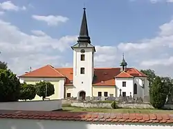 Church of Saint Giles | |
 Flag  Coat of arms | |
 Moutnice Location in the Czech Republic | |
| Coordinates: 49°2′57″N 16°44′15″E / 49.04917°N 16.73750°E | |
| Country | |
| Region | South Moravian |
| District | Brno-Country |
| First mentioned | 1298 |
| Area | |
| • Total | 7.09 km2 (2.74 sq mi) |
| Elevation | 197 m (646 ft) |
| Population (2023-01-01)[1] | |
| • Total | 1,156 |
| • Density | 160/km2 (420/sq mi) |
| Time zone | UTC+1 (CET) |
| • Summer (DST) | UTC+2 (CEST) |
| Postal code | 664 55 |
| Website | www |
Moutnice is a municipality and village in Brno-Country District in the South Moravian Region of the Czech Republic. It has about 1,200 inhabitants.
Moutnice lies approximately 19 kilometres (12 mi) south-east of Brno and 203 km (126 mi) south-east of Prague.
Demographics
As of the 2021 census, the population is 1,104, down 3% from 1,142 in 2011.
| Year | Pop. | ±% |
|---|---|---|
| 1869 | 710 | — |
| 1880 | 824 | +16.1% |
| 1890 | 902 | +9.5% |
| 1900 | 926 | +2.7% |
| 1910 | 1,061 | +14.6% |
| 1921 | 1,060 | −0.1% |
| 1930 | 1,074 | +1.3% |
| 1950 | 1,008 | −6.1% |
| 1961 | 1,118 | +10.9% |
| 1970 | 1,119 | +0.1% |
| 1980 | 1,130 | +1.0% |
| 1991 | 1,054 | −6.7% |
| 2001 | 1,089 | +3.3% |
| 2011 | 1,142 | +4.9% |
| 2021 | 1,104 | −3.3% |
| Source: Censuses[2][3] | ||
References
- ↑ "Population of Municipalities – 1 January 2023". Czech Statistical Office. 2023-05-23.
- ↑ "Historický lexikon obcí České republiky 1869–2011 – Okres Brno-venkov" (in Czech). Czech Statistical Office. 2015-12-21. pp. 1–2.
- ↑ "Population Census 2021: Population by sex". Public Database. Czech Statistical Office. 2021-03-27.
Wikimedia Commons has media related to Moutnice.
This article is issued from Wikipedia. The text is licensed under Creative Commons - Attribution - Sharealike. Additional terms may apply for the media files.