Trboušany | |
|---|---|
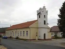 Belfry and kindergarten | |
 Flag  Coat of arms | |
 Trboušany Location in the Czech Republic | |
| Coordinates: 49°3′3″N 16°27′46″E / 49.05083°N 16.46278°E | |
| Country | |
| Region | South Moravian |
| District | Brno-Country |
| First mentioned | 1537 |
| Area | |
| • Total | 5.54 km2 (2.14 sq mi) |
| Elevation | 187 m (614 ft) |
| Population (2023-01-01)[1] | |
| • Total | 386 |
| • Density | 70/km2 (180/sq mi) |
| Time zone | UTC+1 (CET) |
| • Summer (DST) | UTC+2 (CEST) |
| Postal code | 664 64 |
| Website | www |
Trboušany (German: Pausche) is a municipality and village in Brno-Country District in the South Moravian Region of the Czech Republic. It has about 400 inhabitants.
Trboušany lies approximately 21 kilometres (13 mi) south-west of Brno and 187 km (116 mi) south-east of Prague.
References
Wikimedia Commons has media related to Trboušany.
This article is issued from Wikipedia. The text is licensed under Creative Commons - Attribution - Sharealike. Additional terms may apply for the media files.