Boissy-lès-Perche | |
|---|---|
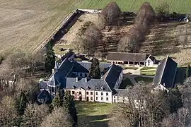 An aerial view of the Cour Pétral | |
Location of Boissy-lès-Perche | |
 Boissy-lès-Perche  Boissy-lès-Perche | |
| Coordinates: 48°41′09″N 0°53′21″E / 48.6858°N 0.8892°E | |
| Country | France |
| Region | Centre-Val de Loire |
| Department | Eure-et-Loir |
| Arrondissement | Dreux |
| Canton | Saint-Lubin-des-Joncherets |
| Intercommunality | Forêts du Perche |
| Government | |
| • Mayor (2020–2026) | Christophe Lefébure[1] |
| Area 1 | 33.66 km2 (13.00 sq mi) |
| Population | 484 |
| • Density | 14/km2 (37/sq mi) |
| Time zone | UTC+01:00 (CET) |
| • Summer (DST) | UTC+02:00 (CEST) |
| INSEE/Postal code | 28046 /28340 |
| Elevation | 165–233 m (541–764 ft) (avg. 188 m or 617 ft) |
| 1 French Land Register data, which excludes lakes, ponds, glaciers > 1 km2 (0.386 sq mi or 247 acres) and river estuaries. | |
Boissy-lès-Perche (French pronunciation: [bwasi lɛ pɛʁʃ], literally Boissy near Perche) is a commune in the Eure-et-Loir department in northern France.
Population
| Year | Pop. | ±% |
|---|---|---|
| 1962 | 435 | — |
| 1968 | 474 | +9.0% |
| 1975 | 418 | −11.8% |
| 1982 | 507 | +21.3% |
| 1990 | 513 | +1.2% |
| 1999 | 534 | +4.1% |
| 2008 | 516 | −3.4% |
See also
References
- ↑ "Répertoire national des élus: les maires" (in French). data.gouv.fr, Plateforme ouverte des données publiques françaises. 13 September 2022.
- ↑ "Populations légales 2021". The National Institute of Statistics and Economic Studies. 28 December 2023.
Wikimedia Commons has media related to Boissy-lès-Perche.
This article is issued from Wikipedia. The text is licensed under Creative Commons - Attribution - Sharealike. Additional terms may apply for the media files.