Villebon | |
|---|---|
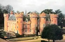 Chateau | |
Location of Villebon | |
 Villebon  Villebon | |
| Coordinates: 48°23′30″N 1°12′26″E / 48.3918°N 1.2071°E | |
| Country | France |
| Region | Centre-Val de Loire |
| Department | Eure-et-Loir |
| Arrondissement | Chartres |
| Canton | Illiers-Combray |
| Government | |
| • Mayor (2020–2026) | Patrick Pétrement[1] |
| Area 1 | 2.16 km2 (0.83 sq mi) |
| Population | 56 |
| • Density | 26/km2 (67/sq mi) |
| Time zone | UTC+01:00 (CET) |
| • Summer (DST) | UTC+02:00 (CEST) |
| INSEE/Postal code | 28414 /28190 |
| Elevation | 182–212 m (597–696 ft) (avg. 180 m or 590 ft) |
| 1 French Land Register data, which excludes lakes, ponds, glaciers > 1 km2 (0.386 sq mi or 247 acres) and river estuaries. | |
Villebon (French pronunciation: [vilbɔ̃] ⓘ) is a commune in the department of Eure-et-Loir in northern France
The inhabitants are called Villebonnais.
Population
| Year | Pop. | ±% p.a. |
|---|---|---|
| 1968 | 47 | — |
| 1975 | 65 | +4.74% |
| 1982 | 45 | −5.12% |
| 1990 | 45 | +0.00% |
| 1999 | 72 | +5.36% |
| 2009 | 76 | +0.54% |
| 2014 | 73 | −0.80% |
| 2020 | 59 | −3.49% |
| Source: INSEE[3] | ||
Personalities
See also
References
- ↑ "Répertoire national des élus: les maires". data.gouv.fr, Plateforme ouverte des données publiques françaises (in French). 2 December 2020.
- ↑ "Populations légales 2021". The National Institute of Statistics and Economic Studies. 28 December 2023.
- ↑ Population en historique depuis 1968, INSEE
Wikimedia Commons has media related to Villebon (Eure-et-Loir).
This article is issued from Wikipedia. The text is licensed under Creative Commons - Attribution - Sharealike. Additional terms may apply for the media files.