Carauari | |
|---|---|
 Flag  Seal | |
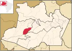 Location of the municipality inside Amazonas | |
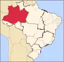
 Carauari Location in Brazil | |
| Coordinates: 4°52′58″S 66°53′45″W / 4.88278°S 66.89583°W | |
| Country | |
| Region | North |
| State | |
| Population (2020) | |
| • Total | 28,508 |
| Time zone | UTC−4 (AMT) |
Carauari is a municipality located in the Brazilian state of Amazonas. Its population was 28,508 (2020)[1] and its area is 25,767 km².[2]
The city is served by Carauari Airport.
Geography
The town is in the Juruá-Purus moist forests ecoregion.[3] The municipality contains about 5% of the Tefé National Forest, created in 1989.[4] The municipality contains 251,577 hectares (621,660 acres) Médio Juruá Extractive Reserve, created in 1997, on the left bank of the meandering Juruá River.[5] It also contains the 632,949 hectares (1,564,050 acres) Uacari Sustainable Development Reserve, created in 2005.[6]
Climate
| Climate data for Carauari | |||||||||||||
|---|---|---|---|---|---|---|---|---|---|---|---|---|---|
| Month | Jan | Feb | Mar | Apr | May | Jun | Jul | Aug | Sep | Oct | Nov | Dec | Year |
| Mean daily maximum °C (°F) | 30.0 (86.0) |
30.4 (86.7) |
30.5 (86.9) |
30.2 (86.4) |
30.9 (87.6) |
30.0 (86.0) |
30.0 (86.0) |
31.5 (88.7) |
31.9 (89.4) |
31.5 (88.7) |
31.0 (87.8) |
30.6 (87.1) |
30.7 (87.3) |
| Daily mean °C (°F) | 25.9 (78.6) |
26.4 (79.5) |
26.4 (79.5) |
26.2 (79.2) |
26.4 (79.5) |
25.8 (78.4) |
25.4 (77.7) |
26.2 (79.2) |
26.7 (80.1) |
26.6 (79.9) |
26.4 (79.5) |
26.3 (79.3) |
26.2 (79.2) |
| Mean daily minimum °C (°F) | 21.9 (71.4) |
22.4 (72.3) |
22.3 (72.1) |
22.3 (72.1) |
21.9 (71.4) |
21.7 (71.1) |
20.9 (69.6) |
21.0 (69.8) |
21.5 (70.7) |
21.8 (71.2) |
21.9 (71.4) |
22.0 (71.6) |
21.8 (71.2) |
| Average precipitation mm (inches) | 301 (11.9) |
242 (9.5) |
320 (12.6) |
307 (12.1) |
231 (9.1) |
126 (5.0) |
89 (3.5) |
105 (4.1) |
153 (6.0) |
195 (7.7) |
235 (9.3) |
283 (11.1) |
2,587 (101.9) |
| Source: http://en.climate-data.org/location/44143/ | |||||||||||||
References
- ↑ IBGE 2020
- ↑ IBGE - "Archived copy". Archived from the original on 2008-06-11. Retrieved 2008-06-11.
{{cite web}}: CS1 maint: archived copy as title (link) - ↑ Sears, Robin, South America: Amazon Basin, northwestern Brazil (NT0133), WWF: World Wildlife Fund, retrieved 2017-03-28
- ↑ FLONA de Tefé (in Portuguese), ISA: Instituto Socioambiental, retrieved 2016-10-19
- ↑ RESEX do Médio Juruá (in Portuguese), ISA: Instituto Socioambiental, retrieved 2016-06-16
- ↑ RDS de Uacari (in Portuguese), ISA: Instituto Socioambiental, retrieved 2016-09-06
Capital: Manaus | ||||||||||||||
| Mesoregion Centro Amazonense |
|  | ||||||||||||
| Mesoregion Norte Amazonense |
| |||||||||||||
| Mesoregion Sudoeste Amazonense |
| |||||||||||||
| Mesoregion Sul Amazonense |
| |||||||||||||
This article is issued from Wikipedia. The text is licensed under Creative Commons - Attribution - Sharealike. Additional terms may apply for the media files.