Itapiranga | |
|---|---|
Municipality | |
 Seal | |
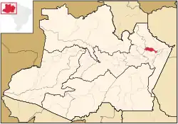 Location of the municipality inside Amazonas | |
| Coordinates: 2°44′56″S 58°1′19″W / 2.74889°S 58.02194°W | |
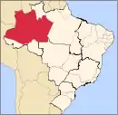
| Country | |
| Region | North |
| State | |
| Area | |
| • Total | 4,231 km2 (1,634 sq mi) |
| Population (2020) | |
| • Total | 9,230 |
| • Density | 2/km2 (5/sq mi) |
| Time zone | UTC−4 (BRT) |
| • Summer (DST) | UTC−4 (DST no longer used) |
Itapiranga is a municipality located in the state of Amazonas northern Brazil on the left bank of the Solimões River about 200 km east of Manaus. Its population was 9,230 (2020)[1] and its area is 4,231 km².[2]
Name
The name is of Indian origin, and was given to a quarry which has a port. It comes from ita, stone and pitanga, red, so the name means "red stone".
Geography
The municipality contains about 40% of the 424,430 hectares (1,048,800 acres) Uatumã Sustainable Development Reserve, which protects the lower part of the Uatumã River basin.[3]
History
It was founded in 1931 as a suburb of Silves.
References
- ↑ IBGE 2020
- ↑ IBGE - "Archived copy". Archived from the original on 2007-01-09. Retrieved 2014-08-03.
{{cite web}}: CS1 maint: archived copy as title (link) - ↑ RDS do Uatumã (in Portuguese), ISA: Instituto Socioambiental, retrieved 2016-07-25
Capital: Manaus | ||||||||||||||
| Mesoregion Centro Amazonense |
|  | ||||||||||||
| Mesoregion Norte Amazonense |
| |||||||||||||
| Mesoregion Sudoeste Amazonense |
| |||||||||||||
| Mesoregion Sul Amazonense |
| |||||||||||||
This article is issued from Wikipedia. The text is licensed under Creative Commons - Attribution - Sharealike. Additional terms may apply for the media files.