Castrelo do Val | |
|---|---|
Municipality | |
 Flag  Seal | |
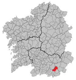 Location in Galicia | |
 Castrelo do Val Location in Spain | |
| Coordinates: 41°59′26″N 7°25′27″W / 41.99056°N 7.42417°W | |
| Country | |
| Autonomous community | |
| Province | |
| Comarca | Verín |
| Government | |
| • Mayor | Vicente Gómez García (Socialists' Party of Galicia) |
| Area | |
| • Total | 122.0 km2 (47.1 sq mi) |
| Elevation | 417 m (1,368 ft) |
| Population (2018)[2] | |
| • Total | 1,001 |
| • Density | 8.2/km2 (21/sq mi) |
| Time zone | UTC+1 (CET) |
| • Summer (DST) | UTC+2 (CEST) |
| INE municipality code | 32021 |
| Website | castrelodoval |
Castrelo do Val (Spanish Castrelo del Valle) is a municipality in Ourense in the Galicia region of north-west Spain. It is located towards the south-east of the province.
References
- ↑ "IGE. Táboas". www.ige.eu (in Galician). Retrieved 2017-10-07.
- ↑ Municipal Register of Spain 2018. National Statistics Institute.
This article is issued from Wikipedia. The text is licensed under Creative Commons - Attribution - Sharealike. Additional terms may apply for the media files.