Kánya | |
|---|---|
Village | |
 Coat of arms | |
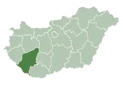
 Kánya Location of Kánya | |
| Coordinates: 46°37′01″N 18°01′01″E / 46.617°N 18.017°E | |
| Country | |
| Region | Southern Transdanubia |
| County | Somogy |
| District | Tab |
| RC Diocese | Pécs[1] |
| Area | |
| • Total | 14.51 km2 (5.60 sq mi) |
| Population (2017) | |
| • Total | 410[2] |
| Demonym | kányai |
| Time zone | UTC+1 (CET) |
| • Summer (DST) | UTC+2 (CEST) |
| Postal code | 8667 |
| Area code | (+36) 84 |
| NUTS 3 code | HU232 |
| MP | Mihály Witzmann (Fidesz) |
| Website | Kánya Online |
Etymology
Its name derives from the name of its owner, Kánya.[3]
External links
References
| Town (1) |
| |
|---|---|---|
| Villages (23) | ||

This article is issued from Wikipedia. The text is licensed under Creative Commons - Attribution - Sharealike. Additional terms may apply for the media files.